
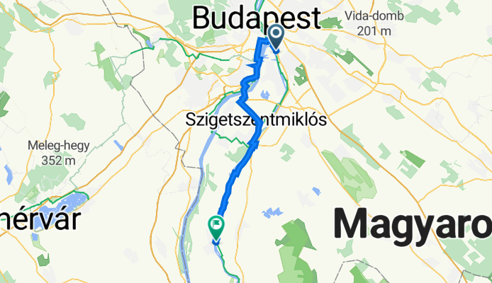
Dalai Láma út 1-12, Budapest to Elnök tér 9, Ráckeve
A cycling route starting in Budapest XX. kerület, Budapest, Hungary.
Overview
About this route
- 4 h 45 min
- Duration
- 50.6 km
- Distance
- 63 m
- Ascent
- 126 m
- Descent
- 10.6 km/h
- Avg. speed
- 151 m
- Max. altitude

Route quality
Waytypes & surfaces along the route
Waytypes
Cycleway
20.7 km
(41 %)
Quiet road
12.1 km
(24 %)
Surfaces
Paved
42.6 km
(84 %)
Unpaved
4.1 km
(8 %)
Asphalt
39.7 km
(78 %)
Paving stones
2.8 km
(6 %)
Continue with Bikemap
Use, edit, or download this cycling route
You would like to ride Dalai Láma út 1-12, Budapest to Elnök tér 9, Ráckeve or customize it for your own trip? Here is what you can do with this Bikemap route:
Free features
- Save this route as favorite or in collections
- Copy & plan your own version of this route
- Sync your route with Garmin or Wahoo
Premium features
Free trial for 3 days, or one-time payment. More about Bikemap Premium.
- Navigate this route on iOS & Android
- Export a GPX / KML file of this route
- Create your custom printout (try it for free)
- Download this route for offline navigation
Discover more Premium features.
Get Bikemap PremiumFrom our community
Other popular routes starting in Budapest XX. kerület
 Baross utca, Budapest - Baross utca, Budapest
- Distance
- 23.8 km
- Ascent
- 99 m
- Descent
- 101 m
- Location
- Budapest XX. kerület, Budapest, Hungary
 Csepel-Csobánka
- Distance
- 35.2 km
- Ascent
- 170 m
- Descent
- 79 m
- Location
- Budapest XX. kerület, Budapest, Hungary
 Erzsébet - Róna utca
- Distance
- 13.3 km
- Ascent
- 17 m
- Descent
- 14 m
- Location
- Budapest XX. kerület, Budapest, Hungary
 Budapest XX. - Dobogókő
- Distance
- 48.1 km
- Ascent
- 553 m
- Descent
- 138 m
- Location
- Budapest XX. kerület, Budapest, Hungary
 Bp-Dömsöd-Bugyi-Ócsa-Bp
- Distance
- 97.4 km
- Ascent
- 56 m
- Descent
- 51 m
- Location
- Budapest XX. kerület, Budapest, Hungary
 Route in Budapest
- Distance
- 11.8 km
- Ascent
- 28 m
- Descent
- 29 m
- Location
- Budapest XX. kerület, Budapest, Hungary
 Erzsébet - Zugló - Megyeri híd
- Distance
- 58.9 km
- Ascent
- 214 m
- Descent
- 213 m
- Location
- Budapest XX. kerület, Budapest, Hungary
 XX. - XI. - XXI. kör
- Distance
- 30.9 km
- Ascent
- 71 m
- Descent
- 74 m
- Location
- Budapest XX. kerület, Budapest, Hungary
Open it in the app