

aiti
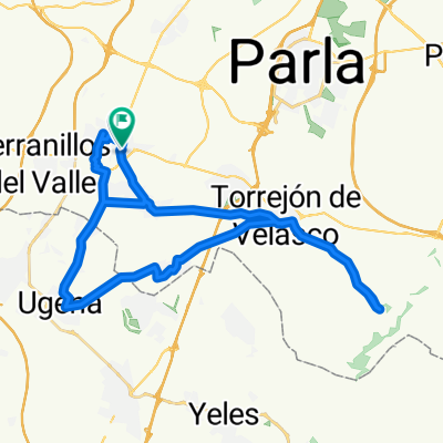
A cycling route starting in Griñón, Madrid, Spain.
Overview
About this route
- -:--
- Duration
- 21.1 km
- Distance
- 114 m
- Ascent
- 113 m
- Descent
- ---
- Avg. speed
- ---
- Max. altitude
Continue with Bikemap
Use, edit, or download this cycling route
You would like to ride aiti or customize it for your own trip? Here is what you can do with this Bikemap route:
Free features
- Save this route as favorite or in collections
- Copy & plan your own version of this route
- Sync your route with Garmin or Wahoo
Premium features
Free trial for 3 days, or one-time payment. More about Bikemap Premium.
- Navigate this route on iOS & Android
- Export a GPX / KML file of this route
- Create your custom printout (try it for free)
- Download this route for offline navigation
Discover more Premium features.
Get Bikemap PremiumFrom our community
Other popular routes starting in Griñón
 De Calle de la Piracanta a Calle de la Piracanta
- Distance
- 42.2 km
- Ascent
- 267 m
- Descent
- 275 m
- Location
- Griñón, Madrid, Spain
 Carretera de Humanes, 16, Griñón a Calle de Severo Ochoa, 7, Humanes de Madrid
- Distance
- 5.9 km
- Ascent
- 14 m
- Descent
- 8 m
- Location
- Griñón, Madrid, Spain
 Ruinas
- Distance
- 33.2 km
- Ascent
- 1,358 m
- Descent
- 1,353 m
- Location
- Griñón, Madrid, Spain
 2019-09-16 Parque Polvoranca
- Distance
- 34.5 km
- Ascent
- 93 m
- Descent
- 95 m
- Location
- Griñón, Madrid, Spain
 De Calle de la Piracanta a Calle Cuesta de la Frontera
- Distance
- 27.8 km
- Ascent
- 141 m
- Descent
- 195 m
- Location
- Griñón, Madrid, Spain
 ugena
ugena- Distance
- 22.9 km
- Ascent
- 317 m
- Descent
- 370 m
- Location
- Griñón, Madrid, Spain
 De Calle Solicampo 3, Griñón a Calle de Vicente Aleixandre 1, Humanes de Madrid
- Distance
- 10 km
- Ascent
- 74 m
- Descent
- 63 m
- Location
- Griñón, Madrid, Spain
 Calle de Córdoba, 1, Griñón a Calle de Méjico, 1, Fuenlabrada
- Distance
- 11.9 km
- Ascent
- 63 m
- Descent
- 87 m
- Location
- Griñón, Madrid, Spain
Open it in the app