
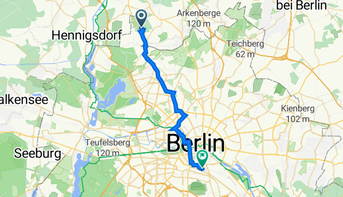
Wildkanzelweg 27, Berlin nach Planufer 77, Berlin
A cycling route starting in Frohnau, Land Berlin, Germany.
Overview
About this route
- 1 h 32 min
- Duration
- 23.9 km
- Distance
- 70 m
- Ascent
- 84 m
- Descent
- 15.5 km/h
- Avg. speed
- 64 m
- Max. altitude

Route quality
Waytypes & surfaces along the route
Waytypes
Quiet road
6.4 km
(27 %)
Busy road
6.4 km
(27 %)
Surfaces
Paved
22.9 km
(96 %)
Unpaved
0.2 km
(<1 %)
Asphalt
18 km
(75 %)
Paving stones
4.6 km
(19 %)
Continue with Bikemap
Use, edit, or download this cycling route
You would like to ride Wildkanzelweg 27, Berlin nach Planufer 77, Berlin or customize it for your own trip? Here is what you can do with this Bikemap route:
Free features
- Save this route as favorite or in collections
- Copy & plan your own version of this route
- Sync your route with Garmin or Wahoo
Premium features
Free trial for 3 days, or one-time payment. More about Bikemap Premium.
- Navigate this route on iOS & Android
- Export a GPX / KML file of this route
- Create your custom printout (try it for free)
- Download this route for offline navigation
Discover more Premium features.
Get Bikemap PremiumFrom our community
Other popular routes starting in Frohnau
 Berlin--Frohnau-Nordost-Runde
- Distance
- 89.4 km
- Ascent
- 286 m
- Descent
- 287 m
- Location
- Frohnau, Land Berlin, Germany
 11. September Geburtstagsrunde Georg
- Distance
- 36.4 km
- Ascent
- 84 m
- Descent
- 90 m
- Location
- Frohnau, Land Berlin, Germany
 70 km nordwestlich über die Dörfer
- Distance
- 72.1 km
- Ascent
- 109 m
- Descent
- 107 m
- Location
- Frohnau, Land Berlin, Germany
 perm Nordkurve
- Distance
- 71.8 km
- Ascent
- 140 m
- Descent
- 140 m
- Location
- Frohnau, Land Berlin, Germany
 Frohnau-Rund um den Krämerforst
- Distance
- 54.1 km
- Ascent
- 103 m
- Descent
- 106 m
- Location
- Frohnau, Land Berlin, Germany
 Rad Frohnau Nord I 18 km
- Distance
- 17.8 km
- Ascent
- 84 m
- Descent
- 83 m
- Location
- Frohnau, Land Berlin, Germany
 perm Nordschleife
- Distance
- 68 km
- Ascent
- 194 m
- Descent
- 202 m
- Location
- Frohnau, Land Berlin, Germany
 Frohnau-Hennigsdorf-Spandau-Gatow-Kladow und zürck
- Distance
- 67.6 km
- Ascent
- 172 m
- Descent
- 188 m
- Location
- Frohnau, Land Berlin, Germany
Open it in the app