

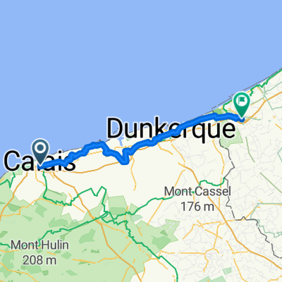
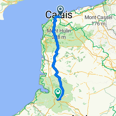
Etapa 029C-2 (Canterbury - Aire sur la Lys)
A cycling route starting in Calais, Hauts-de-France, France.
Overview
About this route
Western Europe Tour. Stage 29 - Part 2
Ferry transfer - FRANCE - Calais - Coulogne - Guînes - Andres - Balinghem - Brêmes - Ardres - Nortkerque - Zutkerque - Recques sur Hem - Bayenghem lès Éperlecques - Éperlecques - Watten - Saint Momelin - Saint Omer - Arques - Wardrecques - Blaringhem - Wittes - Aire sur la Lys
85.3 km
280 m cumulative positive elevation gain
- -:--
- Duration
- 85.3 km
- Distance
- 283 m
- Ascent
- 272 m
- Descent
- ---
- Avg. speed
- 53 m
- Max. altitude

Route quality
Waytypes & surfaces along the route
Waytypes
Quiet road
35.8 km
(42 %)
Path
17.9 km
(21 %)
Surfaces
Paved
48.6 km
(57 %)
Unpaved
2.6 km
(3 %)
Asphalt
39.3 km
(46 %)
Paved (undefined)
5.1 km
(6 %)
Route highlights
Points of interest along the route
Point of interest after 0.8 km
Phare de Calais
Point of interest after 2.2 km
Musée Mémoire 39-45 de Calais
Point of interest after 2.5 km
Hôtel de Ville de Calais
Point of interest after 47.2 km
Le Blockhaus d'Eperlecques
Point of interest after 62 km
Cathédrale Notre-Dame-de-Saint-Omer à Saint-Omer
Accommodation after 85.3 km
Camping La Petite Forêt (62 - Pas de Calais)
Continue with Bikemap
Use, edit, or download this cycling route
You would like to ride Etapa 029C-2 (Canterbury - Aire sur la Lys) or customize it for your own trip? Here is what you can do with this Bikemap route:
Free features
- Save this route as favorite or in collections
- Copy & plan your own version of this route
- Split it into stages to create a multi-day tour
- Sync your route with Garmin or Wahoo
Premium features
Free trial for 3 days, or one-time payment. More about Bikemap Premium.
- Navigate this route on iOS & Android
- Export a GPX / KML file of this route
- Create your custom printout (try it for free)
- Download this route for offline navigation
Discover more Premium features.
Get Bikemap PremiumFrom our community
Other popular routes starting in Calais
 Route #3
- Distance
- 123.6 km
- Ascent
- 0 m
- Descent
- 0 m
- Location
- Calais, Hauts-de-France, France
 Calais nach Veurne
- Distance
- 79.8 km
- Ascent
- 44 m
- Descent
- 44 m
- Location
- Calais, Hauts-de-France, France
 Calais to the Hoek of Holland
- Distance
- 256.2 km
- Ascent
- 31 m
- Descent
- 28 m
- Location
- Calais, Hauts-de-France, France
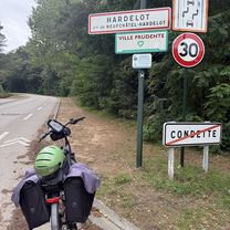 Au Fil de l’Eau - Étape 3 - Calais - Hardelot
- Distance
- 66.6 km
- Ascent
- 651 m
- Descent
- 634 m
- Location
- Calais, Hauts-de-France, France
 Critérium de Calais
- Distance
- 30.1 km
- Ascent
- 191 m
- Descent
- 191 m
- Location
- Calais, Hauts-de-France, France
 Calais to Pauwel Heinderycxstraat, Veurne
- Distance
- 77.3 km
- Ascent
- 45 m
- Descent
- 52 m
- Location
- Calais, Hauts-de-France, France
 Alpe d’Huez Trip
- Distance
- 1,072.3 km
- Ascent
- 7,329 m
- Descent
- 5,556 m
- Location
- Calais, Hauts-de-France, France
 Grey Court 2 Paris Day 2
- Distance
- 121.9 km
- Ascent
- 582 m
- Descent
- 569 m
- Location
- Calais, Hauts-de-France, France
Open it in the app