

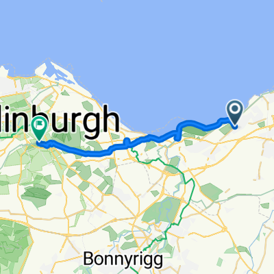
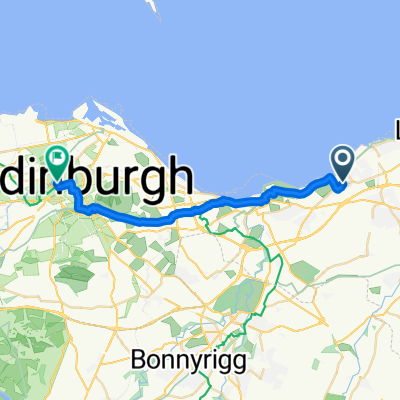
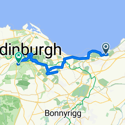
B1348, Drummohr, Prestonpans to 1 Milton Link, Edinburgh
A cycling route starting in Prestonpans, Scotland, United Kingdom.
Overview
About this route
- 41 min
- Duration
- 8.4 km
- Distance
- 55 m
- Ascent
- 39 m
- Descent
- 12.2 km/h
- Avg. speed
- 41 m
- Max. altitude
Route quality
Waytypes & surfaces along the route
Waytypes
Cycleway
4.8 km
(58 %)
Quiet road
1.7 km
(20 %)
Surfaces
Paved
7.4 km
(88 %)
Asphalt
7 km
(84 %)
Paved (undefined)
0.3 km
(4 %)
Undefined
1 km
(12 %)
Continue with Bikemap
Use, edit, or download this cycling route
You would like to ride B1348, Drummohr, Prestonpans to 1 Milton Link, Edinburgh or customize it for your own trip? Here is what you can do with this Bikemap route:
Free features
- Save this route as favorite or in collections
- Copy & plan your own version of this route
- Sync your route with Garmin or Wahoo
Premium features
Free trial for 3 days, or one-time payment. More about Bikemap Premium.
- Navigate this route on iOS & Android
- Export a GPX / KML file of this route
- Create your custom printout (try it for free)
- Download this route for offline navigation
Discover more Premium features.
Get Bikemap PremiumFrom our community
Other popular routes starting in Prestonpans

Edge800®
Prestonpans Cycling- Distance
- 70.9 km
- Ascent
- 964 m
- Descent
- 892 m
- Location
- Prestonpans, Scotland, United Kingdom
 14 The Pottery, High St, Prestonpans to 13 The Pottery, High St, Prestonpans
- Distance
- 54.3 km
- Ascent
- 161 m
- Descent
- 160 m
- Location
- Prestonpans, Scotland, United Kingdom
 Prestonpans to Edinburgh
- Distance
- 16.4 km
- Ascent
- 98 m
- Descent
- 35 m
- Location
- Prestonpans, Scotland, United Kingdom
 13 Mallard Walk, Prestonpans to 1–3 Saint Colme Street, Edinburgh
- Distance
- 17.5 km
- Ascent
- 90 m
- Descent
- 50 m
- Location
- Prestonpans, Scotland, United Kingdom
 Long bike tour from Prestonpans to エディンバラ
- Distance
- 30.5 km
- Ascent
- 313 m
- Descent
- 233 m
- Location
- Prestonpans, Scotland, United Kingdom
 poppyshort2022
- Distance
- 75.9 km
- Ascent
- 0 m
- Descent
- 0 m
- Location
- Prestonpans, Scotland, United Kingdom
 B1348, Drummohr, Prestonpans to 1 Milton Link, Edinburgh
- Distance
- 8.4 km
- Ascent
- 55 m
- Descent
- 39 m
- Location
- Prestonpans, Scotland, United Kingdom
 Pans to Oxton - Club ride in the middle !
- Distance
- 84.5 km
- Ascent
- 506 m
- Descent
- 293 m
- Location
- Prestonpans, Scotland, United Kingdom
Open it in the app