

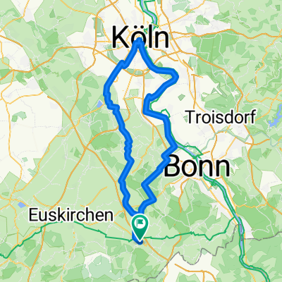
Eifel Große Runde
A cycling route starting in Rheinbach, North Rhine-Westphalia, Germany.
Overview
About this route
- 3 h 10 min
- Duration
- 61.2 km
- Distance
- 517 m
- Ascent
- 570 m
- Descent
- 19.3 km/h
- Avg. speed
- 423 m
- Max. altitude

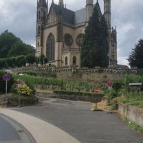
Route photos


Route quality
Waytypes & surfaces along the route
Waytypes
Track
38.6 km
(63 %)
Quiet road
7.3 km
(12 %)
Surfaces
Paved
39.2 km
(64 %)
Unpaved
20.2 km
(33 %)
Asphalt
37.9 km
(62 %)
Gravel
9.8 km
(16 %)
Continue with Bikemap
Use, edit, or download this cycling route
You would like to ride Eifel Große Runde or customize it for your own trip? Here is what you can do with this Bikemap route:
Free features
- Save this route as favorite or in collections
- Copy & plan your own version of this route
- Sync your route with Garmin or Wahoo
Premium features
Free trial for 3 days, or one-time payment. More about Bikemap Premium.
- Navigate this route on iOS & Android
- Export a GPX / KML file of this route
- Create your custom printout (try it for free)
- Download this route for offline navigation
Discover more Premium features.
Get Bikemap PremiumFrom our community
Other popular routes starting in Rheinbach
 Dörfer - Runde
- Distance
- 19.1 km
- Ascent
- 97 m
- Descent
- 149 m
- Location
- Rheinbach, North Rhine-Westphalia, Germany
 Leichte Rundfahrt nördlich von Rheinbach
- Distance
- 15.7 km
- Ascent
- 37 m
- Descent
- 37 m
- Location
- Rheinbach, North Rhine-Westphalia, Germany
 Vischeltal, Ahrtal
- Distance
- 60.4 km
- Ascent
- 857 m
- Descent
- 883 m
- Location
- Rheinbach, North Rhine-Westphalia, Germany
 Zur Siegfähre Teil 1
- Distance
- 25.1 km
- Ascent
- 223 m
- Descent
- 375 m
- Location
- Rheinbach, North Rhine-Westphalia, Germany
 Große Eifel Runde Rheinbach
- Distance
- 143.6 km
- Ascent
- 2,239 m
- Descent
- 2,096 m
- Location
- Rheinbach, North Rhine-Westphalia, Germany
 Sonntags zur Ahr uz
- Distance
- 89.2 km
- Ascent
- 966 m
- Descent
- 963 m
- Location
- Rheinbach, North Rhine-Westphalia, Germany
 Siebengebirge, Oelberg, Linz, Remagen
- Distance
- 90.4 km
- Ascent
- 951 m
- Descent
- 1,004 m
- Location
- Rheinbach, North Rhine-Westphalia, Germany
 Köln Runde
- Distance
- 100.3 km
- Ascent
- 277 m
- Descent
- 278 m
- Location
- Rheinbach, North Rhine-Westphalia, Germany
Open it in the app