

Einführungsrunde 2009
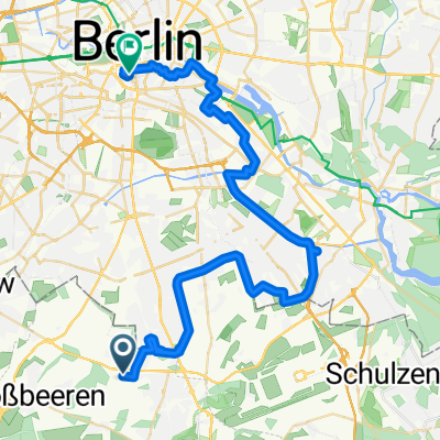
A cycling route starting in Lichtenrade, State of Berlin, Germany.
Overview
About this route
On the Kirchhainer Damm, it's better to use the bike path. It's pretty crappy, but the road is really not fun if you're riding slower than 40 km/h. However, behind the city limits, the bike path (like the road) is very good. The road between Glasow and the old road from Selchow to Tollkrug (where the route bends south) is theoretically closed to cars. Some still drive there, but there's hardly any traffic until Brusendorf. On the B246 between Mittenwalde and Zossen, unfortunately, there is more going on. In Steinstücken, there are still cobblestones of the worst kind, but they are only about 100 meters and you can bypass them on a - also lousy - sidewalk.
- -:--
- Duration
- 104.2 km
- Distance
- 301 m
- Ascent
- 281 m
- Descent
- ---
- Avg. speed
- 66 m
- Max. altitude

Route quality
Waytypes & surfaces along the route
Waytypes
Road
25 km
(24 %)
Quiet road
25 km
(24 %)
Surfaces
Paved
94.8 km
(91 %)
Unpaved
2.1 km
(2 %)
Asphalt
93.8 km
(90 %)
Ground
2.1 km
(2 %)
Route highlights
Points of interest along the route
Point of interest after 20.4 km
Tankstelle
Point of interest after 20.5 km
'Flamingo' - Pasta für unter 4 Euro. Ist nicht gerade haute cuisine, aber durchaus genießbar.
Point of interest after 29.3 km
Pizzeria (irgendwo an der B246), schmeckt ganz ok, an die Preise erinnere ich mich nicht (furchtbar teuer kann es also nicht gewesen sein)
Point of interest after 31.4 km
Tankstelle mit kleinem 'Bistro'
Point of interest after 51 km
Eiscafé (ländliche Variante)
Point of interest after 55.6 km
Spargelhof - Getränke sind billig, aber leider wissen das auch einige lokale Alkis
Point of interest after 82.7 km
Loretta - einer der schönsten Biergärten in Berlin
Point of interest after 103.4 km
Vereinsheim der Rennradgruppe. Der Betreiber glaubt allerdings, es handelte sich um die Cafeteria der TU-Sporthalle.
Continue with Bikemap
Use, edit, or download this cycling route
You would like to ride Einführungsrunde 2009 or customize it for your own trip? Here is what you can do with this Bikemap route:
Free features
- Save this route as favorite or in collections
- Copy & plan your own version of this route
- Split it into stages to create a multi-day tour
- Sync your route with Garmin or Wahoo
Premium features
Free trial for 3 days, or one-time payment. More about Bikemap Premium.
- Navigate this route on iOS & Android
- Export a GPX / KML file of this route
- Create your custom printout (try it for free)
- Download this route for offline navigation
Discover more Premium features.
Get Bikemap PremiumFrom our community
Other popular routes starting in Lichtenrade
 Bornhagenweg, Berlin do Trebbiner Straße, Blankenfelde-Mahlow
- Distance
- 4.2 km
- Ascent
- 6 m
- Descent
- 3 m
- Location
- Lichtenrade, State of Berlin, Germany
 Bornhagenweg, Berlin do Trebbiner Straße, Blankenfelde-Mahlow
- Distance
- 4.3 km
- Ascent
- 16 m
- Descent
- 13 m
- Location
- Lichtenrade, State of Berlin, Germany
 Bornhagenweg, Berlin do Trebbiner Straße, Blankenfelde-Mahlow
- Distance
- 4.1 km
- Ascent
- 10 m
- Descent
- 10 m
- Location
- Lichtenrade, State of Berlin, Germany
 Bornhagenweg, Berlin do Bornhagenweg, Berlin
- Distance
- 8.8 km
- Ascent
- 22 m
- Descent
- 25 m
- Location
- Lichtenrade, State of Berlin, Germany
 Einführungsrunde 2009
- Distance
- 104.2 km
- Ascent
- 301 m
- Descent
- 281 m
- Location
- Lichtenrade, State of Berlin, Germany
 Berlin Tag 1
- Distance
- 45.1 km
- Ascent
- 93 m
- Descent
- 100 m
- Location
- Lichtenrade, State of Berlin, Germany
 Bornhagenweg, Berlin do Trebbiner Straße, Blankenfelde-Mahlow
- Distance
- 4.1 km
- Ascent
- 13 m
- Descent
- 9 m
- Location
- Lichtenrade, State of Berlin, Germany
 Spirdingseestraße, Berlin nach Spirdingseestraße, Berlin
- Distance
- 7.6 km
- Ascent
- 50 m
- Descent
- 52 m
- Location
- Lichtenrade, State of Berlin, Germany
Open it in the app