
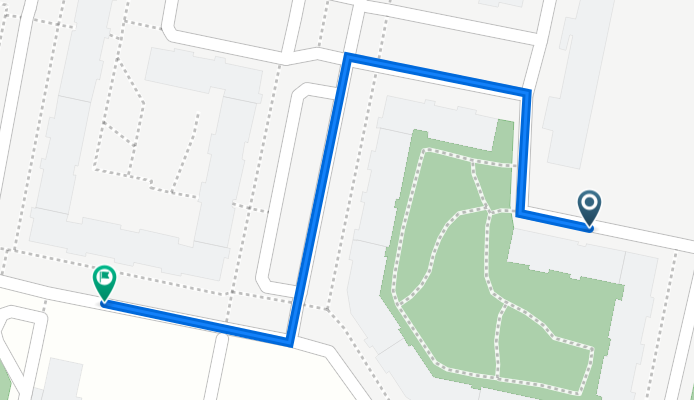
Erich-Kästner-Straße 79, Berlin nach Erich-Kästner-Straße 59, Berlin
A cycling route starting in Hellersdorf, Land Berlin, Germany.
Overview
About this route
- 1 min
- Duration
- 0.3 km
- Distance
- 0 m
- Ascent
- 0 m
- Descent
- 16.9 km/h
- Avg. speed
- 59 m
- Max. altitude

Route quality
Waytypes & surfaces along the route
Waytypes
Quiet road
0.3 km
(86 %)
Access road
0 km
(14 %)
Surfaces
Paved
0.3 km
(100 %)
Asphalt
0.2 km
(78 %)
Paving stones
0 km
(14 %)
Concrete
0 km
(8 %)
Continue with Bikemap
Use, edit, or download this cycling route
You would like to ride Erich-Kästner-Straße 79, Berlin nach Erich-Kästner-Straße 59, Berlin or customize it for your own trip? Here is what you can do with this Bikemap route:
Free features
- Save this route as favorite or in collections
- Copy & plan your own version of this route
- Sync your route with Garmin or Wahoo
Premium features
Free trial for 3 days, or one-time payment. More about Bikemap Premium.
- Navigate this route on iOS & Android
- Export a GPX / KML file of this route
- Create your custom printout (try it for free)
- Download this route for offline navigation
Discover more Premium features.
Get Bikemap PremiumFrom our community
Other popular routes starting in Hellersdorf
 Hönow er Seen
- Distance
- 5.2 km
- Ascent
- 9 m
- Descent
- 10 m
- Location
- Hellersdorf, Land Berlin, Germany
 Von U Hönow nach Eisdiele Altlandsberg
- Distance
- 30.3 km
- Ascent
- 42 m
- Descent
- 40 m
- Location
- Hellersdorf, Land Berlin, Germany
 perm Strausberg Runde
- Distance
- 83.4 km
- Ascent
- 239 m
- Descent
- 238 m
- Location
- Hellersdorf, Land Berlin, Germany
 geführte Radtour für Schulklassen bis 25 Teilnehmer
- Distance
- 21.1 km
- Ascent
- 40 m
- Descent
- 39 m
- Location
- Hellersdorf, Land Berlin, Germany
 Berlin Mehrow Tour
- Distance
- 23.8 km
- Ascent
- 114 m
- Descent
- 112 m
- Location
- Hellersdorf, Land Berlin, Germany
 MTB-Marathon TransMOL
- Distance
- 166.5 km
- Ascent
- 293 m
- Descent
- 312 m
- Location
- Hellersdorf, Land Berlin, Germany
 perm Barnim Runde
- Distance
- 73.2 km
- Ascent
- 161 m
- Descent
- 161 m
- Location
- Hellersdorf, Land Berlin, Germany
 Bad Freienwalde Rundfahrt
- Distance
- 115.9 km
- Ascent
- 424 m
- Descent
- 402 m
- Location
- Hellersdorf, Land Berlin, Germany
Open it in the app