
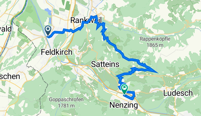
Nofler Straße 56, Feldkirch nach Illstraße 42, Nenzing
A cycling route starting in Nofels, Vorarlberg, Austria.
Overview
About this route
- 1 h 31 min
- Duration
- 31.7 km
- Distance
- 692 m
- Ascent
- 686 m
- Descent
- 20.9 km/h
- Avg. speed
- 1,114 m
- Max. altitude

Route quality
Waytypes & surfaces along the route
Waytypes
Road
13.9 km
(44 %)
Quiet road
9 km
(28 %)
Surfaces
Paved
31.6 km
(100 %)
Asphalt
31.6 km
(100 %)
Wood
0 km
(<1 %)
Continue with Bikemap
Use, edit, or download this cycling route
You would like to ride Nofler Straße 56, Feldkirch nach Illstraße 42, Nenzing or customize it for your own trip? Here is what you can do with this Bikemap route:
Free features
- Save this route as favorite or in collections
- Copy & plan your own version of this route
- Sync your route with Garmin or Wahoo
Premium features
Free trial for 3 days, or one-time payment. More about Bikemap Premium.
- Navigate this route on iOS & Android
- Export a GPX / KML file of this route
- Create your custom printout (try it for free)
- Download this route for offline navigation
Discover more Premium features.
Get Bikemap PremiumFrom our community
Other popular routes starting in Nofels
 Bregenz-Brno day2of9
- Distance
- 94.5 km
- Ascent
- 1,388 m
- Descent
- 978 m
- Location
- Nofels, Vorarlberg, Austria
 Illspitzlauf 2015 (10km)
- Distance
- 9.8 km
- Ascent
- 9 m
- Descent
- 10 m
- Location
- Nofels, Vorarlberg, Austria
 Abendliche Trainigsrunde
- Distance
- 116.6 km
- Ascent
- 1,365 m
- Descent
- 1,278 m
- Location
- Nofels, Vorarlberg, Austria
 Route im Schneckentempo in Feldkirch
- Distance
- 51.4 km
- Ascent
- 1,567 m
- Descent
- 1,551 m
- Location
- Nofels, Vorarlberg, Austria
 Rund um den Schellenberg
- Distance
- 34.4 km
- Ascent
- 25 m
- Descent
- 16 m
- Location
- Nofels, Vorarlberg, Austria
 Von Tisis über Illspitz nach Arbogast und Göfis zurück nach Tisis
- Distance
- 40.6 km
- Ascent
- 398 m
- Descent
- 398 m
- Location
- Nofels, Vorarlberg, Austria
 07_A/Nofels-CH/Sedrun
- Distance
- 130.4 km
- Ascent
- 1,372 m
- Descent
- 417 m
- Location
- Nofels, Vorarlberg, Austria
 Feldkirch - Plansee
- Distance
- 285.8 km
- Ascent
- 2,352 m
- Descent
- 2,352 m
- Location
- Nofels, Vorarlberg, Austria
Open it in the app