

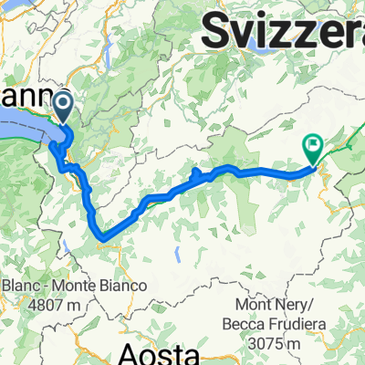
Montreux - Rolle
A cycling route starting in Le Châtelard, Canton of Vaud, Switzerland.
Overview
About this route
Camping Chem. de la Plage 4, 1180 Rolle
- -:--
- Duration
- 52.7 km
- Distance
- 678 m
- Ascent
- 681 m
- Descent
- ---
- Avg. speed
- 572 m
- Max. altitude

Route quality
Waytypes & surfaces along the route
Waytypes
Quiet road
24.8 km
(47 %)
Busy road
11.9 km
(23 %)
Surfaces
Paved
40.7 km
(77 %)
Unpaved
0.6 km
(1 %)
Asphalt
39.1 km
(74 %)
Paved (undefined)
1.2 km
(2 %)
Continue with Bikemap
Use, edit, or download this cycling route
You would like to ride Montreux - Rolle or customize it for your own trip? Here is what you can do with this Bikemap route:
Free features
- Save this route as favorite or in collections
- Copy & plan your own version of this route
- Sync your route with Garmin or Wahoo
Premium features
Free trial for 3 days, or one-time payment. More about Bikemap Premium.
- Navigate this route on iOS & Android
- Export a GPX / KML file of this route
- Create your custom printout (try it for free)
- Download this route for offline navigation
Discover more Premium features.
Get Bikemap PremiumFrom our community
Other popular routes starting in Le Châtelard
 Clarens Villeneuve Chexbres et retour par les hauts
- Distance
- 75.2 km
- Ascent
- 1,709 m
- Descent
- 1,711 m
- Location
- Le Châtelard, Canton of Vaud, Switzerland
 RHONSKOU STEZKOU NA KOLE-www.nomad.cz
- Distance
- 181.2 km
- Ascent
- 1,311 m
- Descent
- 1,056 m
- Location
- Le Châtelard, Canton of Vaud, Switzerland
 Montreux - Chateau de Chillon
- Distance
- 25.2 km
- Ascent
- 927 m
- Descent
- 924 m
- Location
- Le Châtelard, Canton of Vaud, Switzerland
 Vers Chailly
- Distance
- 4 km
- Ascent
- 93 m
- Descent
- 93 m
- Location
- Le Châtelard, Canton of Vaud, Switzerland
 De Route des Colondalles 36, Montreux à Rue du Lac 128A, Montreux
- Distance
- 2.6 km
- Ascent
- 34 m
- Descent
- 0 m
- Location
- Le Châtelard, Canton of Vaud, Switzerland
 trasa NA KOLE OD ŽENEVSKÉHO JEZERA K MATTERHORNU
- Distance
- 117.1 km
- Ascent
- 1,240 m
- Descent
- 1,130 m
- Location
- Le Châtelard, Canton of Vaud, Switzerland
 Clarens-La Guerce
- Distance
- 38.1 km
- Ascent
- 1,023 m
- Descent
- 37 m
- Location
- Le Châtelard, Canton of Vaud, Switzerland
 Montreux - Rolle
- Distance
- 52.7 km
- Ascent
- 678 m
- Descent
- 681 m
- Location
- Le Châtelard, Canton of Vaud, Switzerland
Open it in the app