

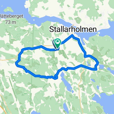
Stenfasta varvet
A cycling route starting in Stallarholmen, Södermanland County, Sweden.
Overview
About this route
Gravel road and cycle path with gravel and asphalt
- -:--
- Duration
- 6.1 km
- Distance
- 56 m
- Ascent
- 57 m
- Descent
- ---
- Avg. speed
- 39 m
- Max. altitude

Route quality
Waytypes & surfaces along the route
Waytypes
Cycleway
3.7 km
(60 %)
Quiet road
2.4 km
(40 %)
Surfaces
Paved
0.6 km
(10 %)
Unpaved
4 km
(66 %)
Unpaved (undefined)
3.2 km
(52 %)
Gravel
0.9 km
(14 %)
Continue with Bikemap
Use, edit, or download this cycling route
You would like to ride Stenfasta varvet or customize it for your own trip? Here is what you can do with this Bikemap route:
Free features
- Save this route as favorite or in collections
- Copy & plan your own version of this route
- Sync your route with Garmin or Wahoo
Premium features
Free trial for 3 days, or one-time payment. More about Bikemap Premium.
- Navigate this route on iOS & Android
- Export a GPX / KML file of this route
- Create your custom printout (try it for free)
- Download this route for offline navigation
Discover more Premium features.
Get Bikemap PremiumFrom our community
Other popular routes starting in Stallarholmen
 Strängnäs via Kärrholmen
- Distance
- 14.9 km
- Ascent
- 135 m
- Descent
- 156 m
- Location
- Stallarholmen, Södermanland County, Sweden
 Mariefred via Haga
- Distance
- 15.4 km
- Ascent
- 175 m
- Descent
- 191 m
- Location
- Stallarholmen, Södermanland County, Sweden
 Gesta-Ytterselö-Valla-Gesta
- Distance
- 11.6 km
- Ascent
- 98 m
- Descent
- 99 m
- Location
- Stallarholmen, Södermanland County, Sweden
 Mariefred via Vånga
- Distance
- 16.8 km
- Ascent
- 190 m
- Descent
- 206 m
- Location
- Stallarholmen, Södermanland County, Sweden
 Hemmavasan Strängnäs 2023 - Start Stallarholmen
- Distance
- 60.7 km
- Ascent
- 704 m
- Descent
- 704 m
- Location
- Stallarholmen, Södermanland County, Sweden
 Kumla viltvatten
- Distance
- 7.5 km
- Ascent
- 55 m
- Descent
- 67 m
- Location
- Stallarholmen, Södermanland County, Sweden
 Jättne viltvatten
- Distance
- 10.6 km
- Ascent
- 88 m
- Descent
- 94 m
- Location
- Stallarholmen, Södermanland County, Sweden
 Björkebyrundan
- Distance
- 20.8 km
- Ascent
- 239 m
- Descent
- 244 m
- Location
- Stallarholmen, Södermanland County, Sweden
Open it in the app