

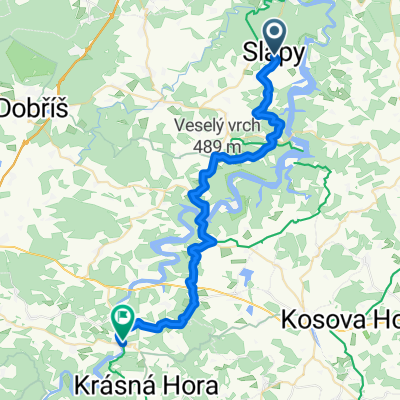
Slapy okruh 1
A cycling route starting in Štěchovice, Central Bohemia, Czechia.
Overview
About this route
The more information you write here, the more useful it will be for other users.* Course of the route.* What is special about this route?* Why recommend this route?* What did you like most here?* Etc.
- -:--
- Duration
- 30.7 km
- Distance
- 869 m
- Ascent
- 869 m
- Descent
- ---
- Avg. speed
- ---
- Max. altitude
Continue with Bikemap
Use, edit, or download this cycling route
You would like to ride Slapy okruh 1 or customize it for your own trip? Here is what you can do with this Bikemap route:
Free features
- Save this route as favorite or in collections
- Copy & plan your own version of this route
- Sync your route with Garmin or Wahoo
Premium features
Free trial for 3 days, or one-time payment. More about Bikemap Premium.
- Navigate this route on iOS & Android
- Export a GPX / KML file of this route
- Create your custom printout (try it for free)
- Download this route for offline navigation
Discover more Premium features.
Get Bikemap PremiumFrom our community
Other popular routes starting in Štěchovice
 Měřín - zámek v Radíči a zpět
- Distance
- 40.1 km
- Ascent
- 600 m
- Descent
- 600 m
- Location
- Štěchovice, Central Bohemia, Czechia
 Slapy 2011/2
- Distance
- 72.3 km
- Ascent
- 1,027 m
- Descent
- 932 m
- Location
- Štěchovice, Central Bohemia, Czechia
 Moderate route in
- Distance
- 21.1 km
- Ascent
- 526 m
- Descent
- 643 m
- Location
- Štěchovice, Central Bohemia, Czechia
 Štěchovice-Živohošť a zpět
- Distance
- 45 km
- Ascent
- 937 m
- Descent
- 909 m
- Location
- Štěchovice, Central Bohemia, Czechia
 002 Slapy - Kamyk nad Vitavou
- Distance
- 35.5 km
- Ascent
- 399 m
- Descent
- 481 m
- Location
- Štěchovice, Central Bohemia, Czechia
 Slapy okruh 1
- Distance
- 30.7 km
- Ascent
- 869 m
- Descent
- 869 m
- Location
- Štěchovice, Central Bohemia, Czechia
 Nová Rabyně - Kamenný Přívoz - Velké Popovice - Mukařov - Český Brod - Sadská - Nymburk - Poděbrady - Chlumec nad Cidlinou
- Distance
- 122.2 km
- Ascent
- 606 m
- Descent
- 671 m
- Location
- Štěchovice, Central Bohemia, Czechia
 Záhorský potok
- Distance
- 19.7 km
- Ascent
- 471 m
- Descent
- 473 m
- Location
- Štěchovice, Central Bohemia, Czechia
Open it in the app