
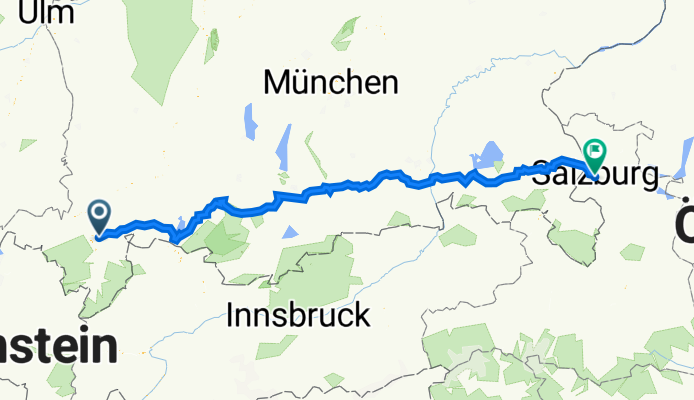
Maler-Weiß-Weg 2A, Rettenberg nach Griesgasse 3, Salzburg
A cycling route starting in Rettenberg, Bavaria, Germany.
Overview
About this route
- 18 h 38 min
- Duration
- 275.2 km
- Distance
- 3,336 m
- Ascent
- 3,699 m
- Descent
- 14.8 km/h
- Avg. speed
- 1,036 m
- Max. altitude
Route quality
Waytypes & surfaces along the route
Waytypes
Quiet road
112.8 km
(41 %)
Path
66 km
(24 %)
Surfaces
Paved
261.4 km
(95 %)
Unpaved
2.8 km
(1 %)
Asphalt
255.9 km
(93 %)
Paved (undefined)
5.5 km
(2 %)
Continue with Bikemap
Use, edit, or download this cycling route
You would like to ride Maler-Weiß-Weg 2A, Rettenberg nach Griesgasse 3, Salzburg or customize it for your own trip? Here is what you can do with this Bikemap route:
Free features
- Save this route as favorite or in collections
- Copy & plan your own version of this route
- Split it into stages to create a multi-day tour
- Sync your route with Garmin or Wahoo
Premium features
Free trial for 3 days, or one-time payment. More about Bikemap Premium.
- Navigate this route on iOS & Android
- Export a GPX / KML file of this route
- Create your custom printout (try it for free)
- Download this route for offline navigation
Discover more Premium features.
Get Bikemap PremiumFrom our community
Other popular routes starting in Rettenberg
 2013-14 Altmühltal - Ammersee - Allgäu Eckarts - Hergatz
- Distance
- 59.5 km
- Ascent
- 364 m
- Descent
- 534 m
- Location
- Rettenberg, Bavaria, Germany
 Feierabendrunde (Nebenstraßen)
- Distance
- 75.6 km
- Ascent
- 584 m
- Descent
- 584 m
- Location
- Rettenberg, Bavaria, Germany
 7.7.2020
- Distance
- 37.4 km
- Ascent
- 644 m
- Descent
- 660 m
- Location
- Rettenberg, Bavaria, Germany
 Radstrecke Heuberg, Martinszell, Oberdorf
- Distance
- 4.3 km
- Ascent
- 85 m
- Descent
- 34 m
- Location
- Rettenberg, Bavaria, Germany
 Freidorf->Kranzegg->Königssträssle->Rossberghütte->Burgberg->zurück
- Distance
- 30.7 km
- Ascent
- 951 m
- Descent
- 892 m
- Location
- Rettenberg, Bavaria, Germany
 Grüntenhütte und Wertacher Hörnle
- Distance
- 26.9 km
- Ascent
- 1,346 m
- Descent
- 1,336 m
- Location
- Rettenberg, Bavaria, Germany
 Gunzesried
- Distance
- 44 km
- Ascent
- 411 m
- Descent
- 402 m
- Location
- Rettenberg, Bavaria, Germany
 Rettenberg-Memmingen-Donaustetten
- Distance
- 116.9 km
- Ascent
- 265 m
- Descent
- 590 m
- Location
- Rettenberg, Bavaria, Germany
Open it in the app