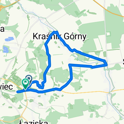
Rynek 41, Boles艂awiec do Kliczk贸w 8, Osiecznica
A cycling route starting in Boles艂awiec, Lower Silesian Voivodeship, Poland.
Overview
About this route
- 1 h 8 min
- Duration
- 19.5 km
- Distance
- 100 m
- Ascent
- 129 m
- Descent
- 17.2 km/h
- Avg. speed
- 202 m
- Avg. speed
Route photos
Route quality
Waytypes & surfaces along the route
Waytypes
Road
9.5 km
(49 %)
Track
5.8 km
(30 %)
Surfaces
Paved
9 km
(46 %)
Unpaved
1.9 km
(10 %)
Asphalt
4.9 km
(25 %)
Paved (undefined)
4.1 km
(21 %)
Continue with Bikemap
Use, edit, or download this cycling route
You would like to ride Rynek 41, Boles艂awiec do Kliczk贸w 8, Osiecznica or customize it for your own trip? Here is what you can do with this Bikemap route:
Free features
- Save this route as favorite or in collections
- Copy & plan your own version of this route
- Sync your route with Garmin or Wahoo
Premium features
Free trial for 3 days, or one-time payment. More about Bikemap Premium.
- Navigate this route on iOS & Android
- Export a GPX / KML file of this route
- Create your custom printout (try it for free)
- Download this route for offline navigation
Discover more Premium features.
Get Bikemap PremiumFrom our community
Other popular routes starting in Boles艂awiec
- Rynek 41, Boles艂awiec do Kliczk贸w 8, Osiecznica
- Distance
- 19.5 km
- Ascent
- 100 m
- Descent
- 129 m
- Location
- Boles艂awiec, Lower Silesian Voivodeship, Poland
- Szlak im. Leona Pi膮tkowskiego p臋tla p贸艂nocna
- Distance
- 28.3 km
- Ascent
- 160 m
- Descent
- 171 m
- Location
- Boles艂awiec, Lower Silesian Voivodeship, Poland
- Boles艂awiec - Suszki petla poludniowa
- Distance
- 31.6 km
- Ascent
- 214 m
- Descent
- 221 m
- Location
- Boles艂awiec, Lower Silesian Voivodeship, Poland
- Okolice Boles艂awca
- Distance
- 389.9 km
- Ascent
- 1,808 m
- Descent
- 1,808 m
- Location
- Boles艂awiec, Lower Silesian Voivodeship, Poland
- I Rowerowy Rajd na Orientacj臋 Warta Boles艂awiecka 2019
- Distance
- 29.7 km
- Ascent
- 104 m
- Descent
- 103 m
- Location
- Boles艂awiec, Lower Silesian Voivodeship, Poland
- Antywyprawka 5 2018
- Distance
- 164.2 km
- Ascent
- 726 m
- Descent
- 727 m
- Location
- Boles艂awiec, Lower Silesian Voivodeship, Poland
- Dolina Bobru
- Distance
- 82.7 km
- Ascent
- 705 m
- Descent
- 554 m
- Location
- Boles艂awiec, Lower Silesian Voivodeship, Poland
- Kruszyn - Zgorzelec
- Distance
- 70.8 km
- Ascent
- 343 m
- Descent
- 333 m
- Location
- Boles艂awiec, Lower Silesian Voivodeship, Poland
Open it in the app