
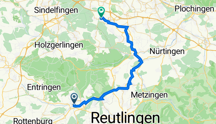
Am Stadtgraben, Tübingen nach Musberger Straße, Leinfelden-Echterdingen
A cycling route starting in Tübingen, Baden-Wurttemberg, Germany.
Overview
About this route
- 2 h 48 min
- Duration
- 40.8 km
- Distance
- 267 m
- Ascent
- 162 m
- Descent
- 14.6 km/h
- Avg. speed
- 437 m
- Max. altitude
Route quality
Waytypes & surfaces along the route
Waytypes
Track
13 km
(32 %)
Cycleway
9 km
(22 %)
Surfaces
Paved
39.9 km
(98 %)
Asphalt
35.5 km
(87 %)
Paved (undefined)
4.1 km
(10 %)
Continue with Bikemap
Use, edit, or download this cycling route
You would like to ride Am Stadtgraben, Tübingen nach Musberger Straße, Leinfelden-Echterdingen or customize it for your own trip? Here is what you can do with this Bikemap route:
Free features
- Save this route as favorite or in collections
- Copy & plan your own version of this route
- Sync your route with Garmin or Wahoo
Premium features
Free trial for 3 days, or one-time payment. More about Bikemap Premium.
- Navigate this route on iOS & Android
- Export a GPX / KML file of this route
- Create your custom printout (try it for free)
- Download this route for offline navigation
Discover more Premium features.
Get Bikemap PremiumFrom our community
Other popular routes starting in Tübingen
 French Quarter to Baggersee
- Distance
- 8.7 km
- Ascent
- 0 m
- Descent
- 0 m
- Location
- Tübingen, Baden-Wurttemberg, Germany
 Tübingen-Holzgerlingen-Altdorf-Herrenberg-Tübingen
- Distance
- 54.5 km
- Ascent
- 457 m
- Descent
- 420 m
- Location
- Tübingen, Baden-Wurttemberg, Germany
 Unbenannte Route
- Distance
- 50.1 km
- Ascent
- 854 m
- Descent
- 853 m
- Location
- Tübingen, Baden-Wurttemberg, Germany
 Feierabendrunde ab Lustnau Tübingen
- Distance
- 34.3 km
- Ascent
- 149 m
- Descent
- 149 m
- Location
- Tübingen, Baden-Wurttemberg, Germany
 Radstrecke Schnupperdistanz Citytriathlon Tübingen
- Distance
- 5.4 km
- Ascent
- 59 m
- Descent
- 40 m
- Location
- Tübingen, Baden-Wurttemberg, Germany
 20220813 Bad Urach a
- Distance
- 48.3 km
- Ascent
- 526 m
- Descent
- 419 m
- Location
- Tübingen, Baden-Wurttemberg, Germany
 ETT 2022 Gesamte Strecke
- Distance
- 877.3 km
- Ascent
- 6,381 m
- Descent
- 6,375 m
- Location
- Tübingen, Baden-Wurttemberg, Germany
 T Ruine Mundeck und mehr
- Distance
- 47.9 km
- Ascent
- 589 m
- Descent
- 598 m
- Location
- Tübingen, Baden-Wurttemberg, Germany
Open it in the app