

18.06 okolice z Misią
A cycling route starting in Tyczyn, Subcarpathian Voivodeship, Poland.
Overview
About this route
null
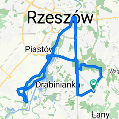
- 1 h 32 min
- Duration
- 18.6 km
- Distance
- 303 m
- Ascent
- 361 m
- Descent
- 12.1 km/h
- Avg. speed
- 356 m
- Max. altitude

Route quality
Waytypes & surfaces along the route
Waytypes
Road
11.7 km
(63 %)
Quiet road
6.5 km
(35 %)
Pedestrian area
0.4 km
(2 %)
Surfaces
Paved
16.6 km
(89 %)
Asphalt
16.6 km
(89 %)
Undefined
2 km
(11 %)
Continue with Bikemap
Use, edit, or download this cycling route
You would like to ride 18.06 okolice z Misią or customize it for your own trip? Here is what you can do with this Bikemap route:
Free features
- Save this route as favorite or in collections
- Copy & plan your own version of this route
- Sync your route with Garmin or Wahoo
Premium features
Free trial for 3 days, or one-time payment. More about Bikemap Premium.
- Navigate this route on iOS & Android
- Export a GPX / KML file of this route
- Create your custom printout (try it for free)
- Download this route for offline navigation
Discover more Premium features.
Get Bikemap PremiumFrom our community
Other popular routes starting in Tyczyn
 Krótsza trasa przez Tyczyn
- Distance
- 18.3 km
- Ascent
- 209 m
- Descent
- 209 m
- Location
- Tyczyn, Subcarpathian Voivodeship, Poland
 Dookola Patrii
- Distance
- 63 km
- Ascent
- 660 m
- Descent
- 682 m
- Location
- Tyczyn, Subcarpathian Voivodeship, Poland
 Zalesie- Przylasek- Boguchwała- Lisia góra
- Distance
- 30.5 km
- Ascent
- 252 m
- Descent
- 256 m
- Location
- Tyczyn, Subcarpathian Voivodeship, Poland
 M Ćwiklińskiej, Rzeszów to M Ćwiklińskiej, Rzeszów
- Distance
- 21.7 km
- Ascent
- 174 m
- Descent
- 174 m
- Location
- Tyczyn, Subcarpathian Voivodeship, Poland
 Matysówka nocą
- Distance
- 21.6 km
- Ascent
- 422 m
- Descent
- 417 m
- Location
- Tyczyn, Subcarpathian Voivodeship, Poland
 Dookoła Rzeszowa 2
- Distance
- 85.6 km
- Ascent
- 605 m
- Descent
- 605 m
- Location
- Tyczyn, Subcarpathian Voivodeship, Poland
 Rzeszów od wschodu
- Distance
- 16.1 km
- Ascent
- 171 m
- Descent
- 171 m
- Location
- Tyczyn, Subcarpathian Voivodeship, Poland
 Niedzielna trasa v1
- Distance
- 11.5 km
- Ascent
- 77 m
- Descent
- 77 m
- Location
- Tyczyn, Subcarpathian Voivodeship, Poland
Open it in the app