

Montélimar to Fournès
A cycling route starting in Montélimar, Auvergne-Rhône-Alpes, France.
Overview
About this route
The first fifty or so kilometers of this ride were outstanding low traffic roads and cycling paths, much of that being along the ViaRhôna, which had some paved and some hard-pack dirt sections. It also included some very low-traffic roads. Overall, the ViaRhôna was a great find.
- 7 h 7 min
- Duration
- 87.4 km
- Distance
- 654 m
- Ascent
- 674 m
- Descent
- 12.3 km/h
- Avg. speed
- 237 m
- Max. altitude

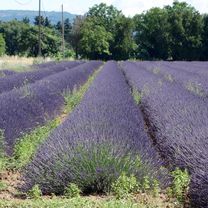
Route photos


Route quality
Waytypes & surfaces along the route
Waytypes
Quiet road
28 km
(32 %)
Cycleway
8.7 km
(10 %)
Surfaces
Paved
51.6 km
(59 %)
Asphalt
50.7 km
(58 %)
Concrete
0.9 km
(1 %)
Undefined
35.8 km
(41 %)
Continue with Bikemap
Use, edit, or download this cycling route
You would like to ride Montélimar to Fournès or customize it for your own trip? Here is what you can do with this Bikemap route:
Free features
- Save this route as favorite or in collections
- Copy & plan your own version of this route
- Split it into stages to create a multi-day tour
- Sync your route with Garmin or Wahoo
Premium features
Free trial for 3 days, or one-time payment. More about Bikemap Premium.
- Navigate this route on iOS & Android
- Export a GPX / KML file of this route
- Create your custom printout (try it for free)
- Download this route for offline navigation
Discover more Premium features.
Get Bikemap PremiumFrom our community
Other popular routes starting in Montélimar
 6- Montélimar - Roquemaure
- Distance
- 76.6 km
- Ascent
- 12 m
- Descent
- 64 m
- Location
- Montélimar, Auvergne-Rhône-Alpes, France
 2016 Ride Day 97 - Montélimar Circle to East
- Distance
- 64.8 km
- Ascent
- 548 m
- Descent
- 548 m
- Location
- Montélimar, Auvergne-Rhône-Alpes, France
 C'est beau le Niger (provençal) à vélo 2016
- Distance
- 365.8 km
- Ascent
- 2,835 m
- Descent
- 2,886 m
- Location
- Montélimar, Auvergne-Rhône-Alpes, France
 Etape 4 : Montelimar ==> Pont ST Esprit
- Distance
- 47.9 km
- Ascent
- 50 m
- Descent
- 76 m
- Location
- Montélimar, Auvergne-Rhône-Alpes, France
 Montelimar - Mont Ventoux
- Distance
- 153.9 km
- Ascent
- 1,895 m
- Descent
- 83 m
- Location
- Montélimar, Auvergne-Rhône-Alpes, France
 2016 Ride Day 98 - Montélimar to Vesc
- Distance
- 42.6 km
- Ascent
- 613 m
- Descent
- 101 m
- Location
- Montélimar, Auvergne-Rhône-Alpes, France
 Montelimar (col Ardeche)
- Distance
- 55.7 km
- Ascent
- 840 m
- Descent
- 845 m
- Location
- Montélimar, Auvergne-Rhône-Alpes, France
 13. Tag Saint Julien du Gua - Saint Nazaire en Royans
- Distance
- 103.8 km
- Ascent
- 219 m
- Descent
- 132 m
- Location
- Montélimar, Auvergne-Rhône-Alpes, France
Open it in the app