

湯の鶴コース
A cycling route starting in Minamata, Kumamoto, Japan.
Overview
About this route
null
- -:--
- Duration
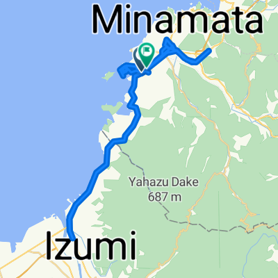
- 4.2 km
- Distance
- 133 m
- Ascent
- 134 m
- Descent
- ---
- Avg. speed
- 205 m
- Max. altitude

Route quality
Waytypes & surfaces along the route
Waytypes
Quiet road
2.9 km
(70 %)
Undefined
1.3 km
(30 %)
Continue with Bikemap
Use, edit, or download this cycling route
You would like to ride 湯の鶴コース or customize it for your own trip? Here is what you can do with this Bikemap route:
Free features
- Save this route as favorite or in collections
- Copy & plan your own version of this route
- Sync your route with Garmin or Wahoo
Premium features
Free trial for 3 days, or one-time payment. More about Bikemap Premium.
- Navigate this route on iOS & Android
- Export a GPX / KML file of this route
- Create your custom printout (try it for free)
- Download this route for offline navigation
Discover more Premium features.
Get Bikemap PremiumFrom our community
Other popular routes starting in Minamata
 aaaaaa
- Distance
- 4.2 km
- Ascent
- 133 m
- Descent
- 134 m
- Location
- Minamata, Kumamoto, Japan
 湯の鶴コース
- Distance
- 4.2 km
- Ascent
- 133 m
- Descent
- 134 m
- Location
- Minamata, Kumamoto, Japan
 27. Route (lang, hoch)
- Distance
- 62.2 km
- Ascent
- 509 m
- Descent
- 631 m
- Location
- Minamata, Kumamoto, Japan
 県道340号, Minamata to 県道340号, Minamata
- Distance
- 148.3 km
- Ascent
- 2,001 m
- Descent
- 2,000 m
- Location
- Minamata, Kumamoto, Japan
 2丁目 まで2丁目
- Distance
- 61 km
- Ascent
- 589 m
- Descent
- 621 m
- Location
- Minamata, Kumamoto, Japan
 湯の児コース
- Distance
- 7.6 km
- Ascent
- 256 m
- Descent
- 256 m
- Location
- Minamata, Kumamoto, Japan
 8, Saiwaimachi, Minamata to Nanaura Orange Road, Tsunagi, Ashikita-Gun
- Distance
- 4.5 km
- Ascent
- 72 m
- Descent
- 78 m
- Location
- Minamata, Kumamoto, Japan
 県道340号, Minamata-Shi to 県道340号, Minamata-Shi
- Distance
- 75.3 km
- Ascent
- 761 m
- Descent
- 759 m
- Location
- Minamata, Kumamoto, Japan
Open it in the app