

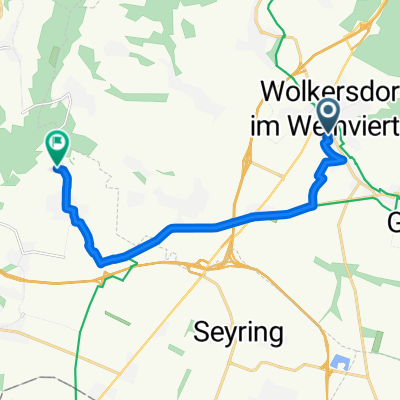
Genussvolle Runde durch das Kreuttal
A cycling route starting in Wolkersdorf im Weinviertel, Lower Austria, Austria.
Overview
About this route
- -:--
- Duration
- 43.9 km
- Distance
- 275 m
- Ascent
- 277 m
- Descent
- ---
- Avg. speed
- 276 m
- Max. altitude

Route quality
Waytypes & surfaces along the route
Waytypes
Quiet road
13.2 km
(30 %)
Track
13.2 km
(30 %)
Surfaces
Paved
32.9 km
(75 %)
Unpaved
6.1 km
(14 %)
Asphalt
31.2 km
(71 %)
Gravel
6.1 km
(14 %)
Route highlights
Points of interest along the route
Drinking water after 6.6 km
Weinviertel Rastplatz Unterolberndorf
Photo after 8.9 km
Luisenmühle
Point of interest after 23.2 km
Weinviertel Rastplatz Stetten
Point of interest after 24.7 km
Mittagessen Hotel Restaurant Schweinberger
Point of interest after 28.2 km
Derzeit: BAUSTELLE - Vorsicht
Point of interest after 32.9 km
Dampfross & Drahtesel
Point of interest after 35.2 km
Dampfross & Drahtesel: Rastplatz Verkehrszeichen
Point of interest after 36.9 km
Dampfross & Drahtesel: Infopoint Greenways, EV9, Europasäule, Rastplatz
Point of interest after 39.7 km
Dampfross & Drahtesel: Großer Rastplatz und Infopoint
Continue with Bikemap
Use, edit, or download this cycling route
You would like to ride Genussvolle Runde durch das Kreuttal or customize it for your own trip? Here is what you can do with this Bikemap route:
Free features
- Save this route as favorite or in collections
- Copy & plan your own version of this route
- Sync your route with Garmin or Wahoo
Premium features
Free trial for 3 days, or one-time payment. More about Bikemap Premium.
- Navigate this route on iOS & Android
- Export a GPX / KML file of this route
- Create your custom printout (try it for free)
- Download this route for offline navigation
Discover more Premium features.
Get Bikemap PremiumFrom our community
Other popular routes starting in Wolkersdorf im Weinviertel
 Korneuburg
- Distance
- 51.6 km
- Ascent
- 120 m
- Descent
- 120 m
- Location
- Wolkersdorf im Weinviertel, Lower Austria, Austria
 Untere Hofgärten, Wolkersdorf im Weinviertel nach Untere Hofgärten, Wolkersdorf im Weinviertel
- Distance
- 6.3 km
- Ascent
- 37 m
- Descent
- 37 m
- Location
- Wolkersdorf im Weinviertel, Lower Austria, Austria
 Runde Wolkersdorf-Unterolberndorf
- Distance
- 33.7 km
- Ascent
- 492 m
- Descent
- 492 m
- Location
- Wolkersdorf im Weinviertel, Lower Austria, Austria
 Rendezvpus
- Distance
- 35 km
- Ascent
- 37 m
- Descent
- 38 m
- Location
- Wolkersdorf im Weinviertel, Lower Austria, Austria
 Autumnable Gravel mit Wieneinfahrt.
- Distance
- 50.3 km
- Ascent
- 316 m
- Descent
- 404 m
- Location
- Wolkersdorf im Weinviertel, Lower Austria, Austria
 Energie graveln. Sunny Side.
- Distance
- 16.7 km
- Ascent
- 117 m
- Descent
- 182 m
- Location
- Wolkersdorf im Weinviertel, Lower Austria, Austria
 Windischhütte über Kahlenberg
- Distance
- 83.6 km
- Ascent
- 1,153 m
- Descent
- 1,150 m
- Location
- Wolkersdorf im Weinviertel, Lower Austria, Austria
 Kühltal nach Neustiftkeller Enzersfeld
- Distance
- 11.9 km
- Ascent
- 73 m
- Descent
- 23 m
- Location
- Wolkersdorf im Weinviertel, Lower Austria, Austria
Open it in the app