
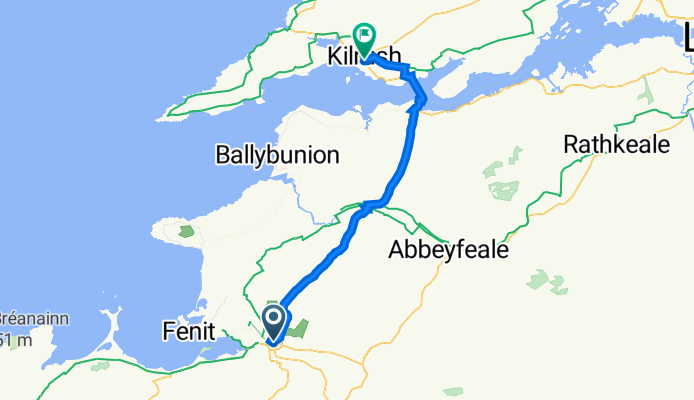
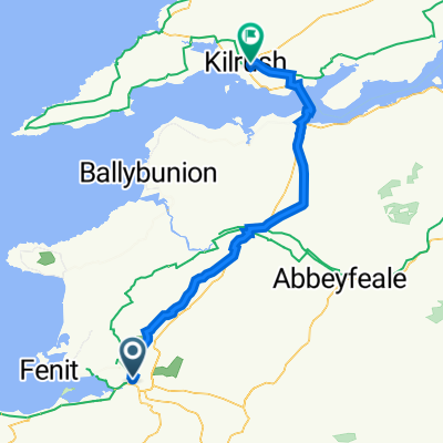
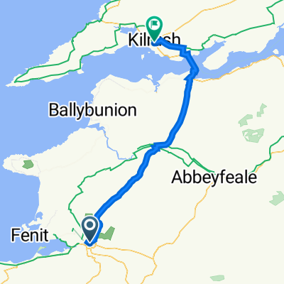
Tralee Kilrush
A cycling route starting in Tralee, Munster, Ireland.
Overview
About this route
- -:--
- Duration
- 60.4 km
- Distance
- 404 m
- Ascent
- 406 m
- Descent
- ---
- Avg. speed
- 142 m
- Max. altitude

Continue with Bikemap
Use, edit, or download this cycling route
You would like to ride Tralee Kilrush or customize it for your own trip? Here is what you can do with this Bikemap route:
Free features
- Save this route as favorite or in collections
- Copy & plan your own version of this route
- Sync your route with Garmin or Wahoo
Premium features
Free trial for 3 days, or one-time payment. More about Bikemap Premium.
- Navigate this route on iOS & Android
- Export a GPX / KML file of this route
- Create your custom printout (try it for free)
- Download this route for offline navigation
Discover more Premium features.
Get Bikemap PremiumFrom our community
Other popular routes starting in Tralee
 Irland 2002 von Tralee nach Doolin am 25.09.02
- Distance
- 140.4 km
- Ascent
- 645 m
- Descent
- 593 m
- Location
- Tralee, Munster, Ireland
 5 Tralee - Tarbert
- Distance
- 59.2 km
- Ascent
- 343 m
- Descent
- 341 m
- Location
- Tralee, Munster, Ireland
 banna bulloch hill
- Distance
- 39.3 km
- Ascent
- 248 m
- Descent
- 235 m
- Location
- Tralee, Munster, Ireland
 tralee to banna
- Distance
- 19.1 km
- Ascent
- 126 m
- Descent
- 127 m
- Location
- Tralee, Munster, Ireland
 Tralee Kilurst
- Distance
- 62.8 km
- Ascent
- 525 m
- Descent
- 519 m
- Location
- Tralee, Munster, Ireland
 Tralee Kilrush
- Distance
- 60.4 km
- Ascent
- 404 m
- Descent
- 406 m
- Location
- Tralee, Munster, Ireland
 Irland Tour 6a- Tralee-Tarbert (Fähre)
- Distance
- 50.4 km
- Ascent
- 318 m
- Descent
- 312 m
- Location
- Tralee, Munster, Ireland
 06/01/23 - 20/01/23
- Distance
- 1,010.7 km
- Ascent
- 7,091 m
- Descent
- 7,040 m
- Location
- Tralee, Munster, Ireland
Open it in the app