

Arcas del Villar ida y vuelta
A cycling route starting in Villar de Olalla, Castille-La Mancha, Spain.
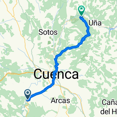
Overview
About this route
Ideal route for a pleasant ride with low difficulty, very few meters of road link, last kilometers of the route downhill. In the pine area it's beautiful, I recommend you pedal calmly while looking at the cistuses, pines, and cork oaks. Route NOT recommended with mud.
- -:--
- Duration
- 11.7 km
- Distance
- 122 m
- Ascent
- 118 m
- Descent
- ---
- Avg. speed
- ---
- Max. altitude
Route quality
Waytypes & surfaces along the route
Waytypes
Track
9.1 km
(78 %)
Quiet road
1.3 km
(11 %)
Undefined
1.3 km
(11 %)
Surfaces
Unpaved
9.1 km
(78 %)
Ground
8.8 km
(75 %)
Gravel
0.4 km
(3 %)
Undefined
2.6 km
(22 %)
Route highlights
Points of interest along the route

Photo after 0 km
Iglesia Románica de Arcas del Villar
Point of interest after 3.9 km
Continue with Bikemap
Use, edit, or download this cycling route
You would like to ride Arcas del Villar ida y vuelta or customize it for your own trip? Here is what you can do with this Bikemap route:
Free features
- Save this route as favorite or in collections
- Copy & plan your own version of this route
- Sync your route with Garmin or Wahoo
Premium features
Free trial for 3 days, or one-time payment. More about Bikemap Premium.
- Navigate this route on iOS & Android
- Export a GPX / KML file of this route
- Create your custom printout (try it for free)
- Download this route for offline navigation
Discover more Premium features.
Get Bikemap PremiumFrom our community
Other popular routes starting in Villar de Olalla
 Senderos de Tórtola: Desde Tórtola hasta Valdeganga de Cuenca
- Distance
- 6.5 km
- Ascent
- 141 m
- Descent
- 204 m
- Location
- Villar de Olalla, Castille-La Mancha, Spain
 Senderos de Tórtola: Desde Tórtola a Olmedilla de Arcas y Vuelta a Tórtola
- Distance
- 17.5 km
- Ascent
- 368 m
- Descent
- 376 m
- Location
- Villar de Olalla, Castille-La Mancha, Spain
 cuenca-hortizuela-naharros-cuenca
- Distance
- 99.4 km
- Ascent
- 987 m
- Descent
- 987 m
- Location
- Villar de Olalla, Castille-La Mancha, Spain
 Villar de Olalla - Villalba de la Sierra
- Distance
- 46.5 km
- Ascent
- 414 m
- Descent
- 185 m
- Location
- Villar de Olalla, Castille-La Mancha, Spain
 De Plaza Mayor, 2, Arcas a Calle Castelar, 3, Fuentes
- Distance
- 11.2 km
- Ascent
- 137 m
- Descent
- 78 m
- Location
- Villar de Olalla, Castille-La Mancha, Spain
 Senderos de Tórtola: Desde Tórtola hasta Villar del Saz de Arcas I
- Distance
- 9.1 km
- Ascent
- 275 m
- Descent
- 91 m
- Location
- Villar de Olalla, Castille-La Mancha, Spain
 Tórtola - Villar del Saz - Olmeda del Rey - Valeria - Parra de las Vegas - Valdeganga de Cuenca - Tórtola
- Distance
- 56.3 km
- Ascent
- 643 m
- Descent
- 644 m
- Location
- Villar de Olalla, Castille-La Mancha, Spain
 Senderos de Tórtola: Desde Tórtola hasta Villar del Saz de Arcas II
- Distance
- 6.7 km
- Ascent
- 211 m
- Descent
- 67 m
- Location
- Villar de Olalla, Castille-La Mancha, Spain
Open it in the app