

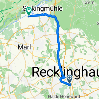
Johann-Sebastian-Bach-Straße 23, Recklinghausen nach Paul-Baumann-Straße 1, Marl
A cycling route starting in Recklinghausen, North Rhine-Westphalia, Germany.
Overview
About this route
- 29 min
- Duration
- 11.1 km
- Distance
- 41 m
- Ascent
- 91 m
- Descent
- 22.7 km/h
- Avg. speed
- 108 m
- Max. altitude

Route quality
Waytypes & surfaces along the route
Waytypes
Quiet road
4.9 km
(44 %)
Road
2.7 km
(24 %)
Surfaces
Paved
7.9 km
(71 %)
Unpaved
0.1 km
(1 %)
Asphalt
7.9 km
(71 %)
Gravel
0.1 km
(1 %)
Undefined
3.1 km
(28 %)
Continue with Bikemap
Use, edit, or download this cycling route
You would like to ride Johann-Sebastian-Bach-Straße 23, Recklinghausen nach Paul-Baumann-Straße 1, Marl or customize it for your own trip? Here is what you can do with this Bikemap route:
Free features
- Save this route as favorite or in collections
- Copy & plan your own version of this route
- Sync your route with Garmin or Wahoo
Premium features
Free trial for 3 days, or one-time payment. More about Bikemap Premium.
- Navigate this route on iOS & Android
- Export a GPX / KML file of this route
- Create your custom printout (try it for free)
- Download this route for offline navigation
Discover more Premium features.
Get Bikemap PremiumFrom our community
Other popular routes starting in Recklinghausen
 13.05.2008 - 20:02
- Distance
- 23.8 km
- Ascent
- 61 m
- Descent
- 61 m
- Location
- Recklinghausen, North Rhine-Westphalia, Germany
 Recklinghausen Marl
- Distance
- 13.5 km
- Ascent
- 130 m
- Descent
- 143 m
- Location
- Recklinghausen, North Rhine-Westphalia, Germany
 R9_21-Suderw-Brandh-RHK-König-Ludw-Südpark-Schimmelsh-Hillerheide
- Distance
- 21.6 km
- Ascent
- 66 m
- Descent
- 66 m
- Location
- Recklinghausen, North Rhine-Westphalia, Germany
 Ludgerusstraße nach Borg
- Distance
- 52.2 km
- Ascent
- 136 m
- Descent
- 200 m
- Location
- Recklinghausen, North Rhine-Westphalia, Germany
 Überschall-Route
- Distance
- 16.6 km
- Ascent
- 67 m
- Descent
- 139 m
- Location
- Recklinghausen, North Rhine-Westphalia, Germany
 Ludgerusstraße nach Schloß Nordkirchen
- Distance
- 33.5 km
- Ascent
- 114 m
- Descent
- 118 m
- Location
- Recklinghausen, North Rhine-Westphalia, Germany
 In den Heuwiesen 34, Recklinghausen nach Blitzkuhlenstraße 123, Recklinghausen
- Distance
- 34.8 km
- Ascent
- 145 m
- Descent
- 159 m
- Location
- Recklinghausen, North Rhine-Westphalia, Germany
 Recklinghausen - Gelsenkirchen
- Distance
- 16.8 km
- Ascent
- 41 m
- Descent
- 93 m
- Location
- Recklinghausen, North Rhine-Westphalia, Germany
Open it in the app