

2023-06-20 Veloscenie 01
A cycling route starting in Thiron Gardais, Centre-Val de Loire, France.
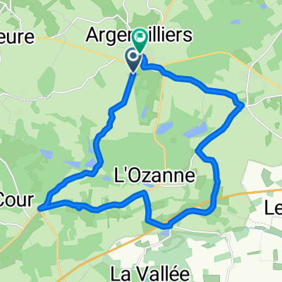
Overview
About this route
null
- 1 h 34 min
- Duration
- 19 km
- Distance
- 181 m
- Ascent
- 312 m
- Descent
- 12.1 km/h
- Avg. speed
- 278 m
- Max. altitude

Route quality
Waytypes & surfaces along the route
Waytypes
Road
12 km
(63 %)
Quiet road
5.3 km
(28 %)
Surfaces
Paved
16.4 km
(86 %)
Asphalt
16.4 km
(86 %)
Undefined
2.6 km
(14 %)
Continue with Bikemap
Use, edit, or download this cycling route
You would like to ride 2023-06-20 Veloscenie 01 or customize it for your own trip? Here is what you can do with this Bikemap route:
Free features
- Save this route as favorite or in collections
- Copy & plan your own version of this route
- Sync your route with Garmin or Wahoo
Premium features
Free trial for 3 days, or one-time payment. More about Bikemap Premium.
- Navigate this route on iOS & Android
- Export a GPX / KML file of this route
- Create your custom printout (try it for free)
- Download this route for offline navigation
Discover more Premium features.
Get Bikemap PremiumFrom our community
Other popular routes starting in Thiron Gardais
 Brunelles - Beauséjour dag 4 LM roadtrip
- Distance
- 81.4 km
- Ascent
- 273 m
- Descent
- 469 m
- Location
- Thiron Gardais, Centre-Val de Loire, France
 ET4 Thiron Gardais - Montagne Perche
- Distance
- 58.2 km
- Ascent
- 460 m
- Descent
- 454 m
- Location
- Thiron Gardais, Centre-Val de Loire, France
 De Rue de la Tuilerie à Rue de la Tuilerie
- Distance
- 3.8 km
- Ascent
- 72 m
- Descent
- 105 m
- Location
- Thiron Gardais, Centre-Val de Loire, France
 Thiron-Gardais / Nogent-le-Rotrou
- Distance
- 19 km
- Ascent
- 210 m
- Descent
- 346 m
- Location
- Thiron Gardais, Centre-Val de Loire, France
 Aprèm 3b
- Distance
- 15.5 km
- Ascent
- 236 m
- Descent
- 247 m
- Location
- Thiron Gardais, Centre-Val de Loire, France
 2023-06-20 Veloscenie 01
- Distance
- 19 km
- Ascent
- 181 m
- Descent
- 312 m
- Location
- Thiron Gardais, Centre-Val de Loire, France
 Stage 10 Thiron-Gardais to Nogent-le-Rotrou
- Distance
- 19 km
- Ascent
- 140 m
- Descent
- 276 m
- Location
- Thiron Gardais, Centre-Val de Loire, France
 De Rue du Gén de Gaulle à Rue de la Tuilerie
- Distance
- 16.7 km
- Ascent
- 297 m
- Descent
- 347 m
- Location
- Thiron Gardais, Centre-Val de Loire, France
Open it in the app