
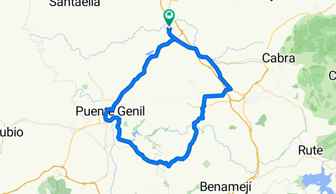
Aguilar-Jauja-P.genil-Aguilar
A cycling route starting in Aguilar, Andalusia, Spain.
Overview
About this route
- -:--
- Duration
- 80.8 km
- Distance
- 711 m
- Ascent
- 721 m
- Descent
- ---
- Avg. speed
- ---
- Avg. speed
Continue with Bikemap
Use, edit, or download this cycling route
You would like to ride Aguilar-Jauja-P.genil-Aguilar or customize it for your own trip? Here is what you can do with this Bikemap route:
Free features
- Save this route as favorite or in collections
- Copy & plan your own version of this route
- Sync your route with Garmin or Wahoo
Premium features
Free trial for 3 days, or one-time payment. More about Bikemap Premium.
- Navigate this route on iOS & Android
- Export a GPX / KML file of this route
- Create your custom printout (try it for free)
- Download this route for offline navigation
Discover more Premium features.
Get Bikemap PremiumFrom our community
Other popular routes starting in Aguilar
 Ruta de las Lagunas
- Distance
- 24.6 km
- Ascent
- 292 m
- Descent
- 292 m
- Location
- Aguilar, Andalusia, Spain
 Aguilar-Montilla Pasando por la romeria y el cementerio CLONED FROM ROUTE 1520820
- Distance
- 28.5 km
- Ascent
- 433 m
- Descent
- 433 m
- Location
- Aguilar, Andalusia, Spain
 benameji
- Distance
- 79.1 km
- Ascent
- 746 m
- Descent
- 763 m
- Location
- Aguilar, Andalusia, Spain
 Aguilar-Jauja-P.genil-Aguilar
- Distance
- 80.8 km
- Ascent
- 711 m
- Descent
- 721 m
- Location
- Aguilar, Andalusia, Spain
 aguilar malaga
- Distance
- 160.9 km
- Ascent
- 831 m
- Descent
- 1,129 m
- Location
- Aguilar, Andalusia, Spain
 Nueva Carteya, Zuheros, Cabra
- Distance
- 81.9 km
- Ascent
- 743 m
- Descent
- 738 m
- Location
- Aguilar, Andalusia, Spain
 agcerr 2013 prueba
- Distance
- 117.6 km
- Ascent
- 1,329 m
- Descent
- 1,329 m
- Location
- Aguilar, Andalusia, Spain
 Vuelta a España Etapa 4 Aguilar de la Frontera Valde Peñas de Jaen
- Distance
- 171.4 km
- Ascent
- 2,237 m
- Descent
- 1,692 m
- Location
- Aguilar, Andalusia, Spain
Open it in the app