100_Meilen_2
- 17 km
- 23 m
- 14 m
- Plänterwald, State of Berlin, Germany
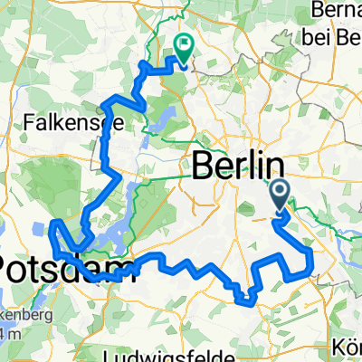
A cycling route starting in Plänterwald, State of Berlin, Germany.
Overview
In Lichtenrade, you can easily shorten the route by not turning left into Kirchhainer Damm and instead going straight through Horstwalder Straße. The very brave can also turn right into a field path at Roter Dudel, which is indeed secured by a semi-automatic level crossing. In Zehlendorf/Düppel/Dreilinden, the Mauerweg (Königsweg) is not suitable for mountain biking, so the southern detour is necessary. The diversions along the Stammbahn are partly not suitable for any bike - but you can certainly push for a few meters. It is especially worth it here... In Griebnitzsee, some antisocial landowners have blocked the lakeside path, so you will probably have to take a detour. Rosa-Luxemburg-Str has a nice name, is low-traffic, and you also tackle a gentle hill. (IMHO, the city of Potsdam should counter the presumably illegal closure of the lakeside path by selling Karl-Marx-Str to an investor, who could then also block access to their properties for the rich. If they refer to the right of way, they should also abide by it themselves.)
created this 16 years ago
Route quality
Path
58.7 km
(42 %)
Quiet road
36.3 km
(26 %)
Paved
109 km
(78 %)
Unpaved
14 km
(10 %)
Asphalt
104.8 km
(75 %)
Ground
8.4 km
(6 %)
Route highlights
'Dörferblick' - die Auffahrt ist zwar wegen merkwürdiger Regenwasserabflußrinnen (könnten auch subtile Fahrradsperren sein) beschwerlich (und zudem stellenweise recht steil), aber die Aussicht über die BBI Baustelle, die Dörfer im Süden und natürlich Neukölln lohnt die Mühe allemal...
Abkürzung: geradeaus durch die Horstwalder Straße fahren
Feldweg des Grauens. Aber mit Bahnübergang.
Gehege zweier Esel.
Brücke über die stillgelegte Friedhofsbahn mit Blick auf den ebenfalls stillgelegten S-Bhf Dreilinden.
Brücke des Königswegs über die stillgelegte Friedhofsbahn; eine Stromschiene ist noch zu sehen.
Brücke der stillgelegten Stammbahn über die stillgelegte Autobahn. Sehenswert!
Steinstücken - West-Berliner Exklave in der DDR. Wurde nach der Mauerbau von der US Armee aus der Luft versorgt.
Klein Glienicke, DDR-Exklave in West-Berlin - war aber durch eine Brücke mit der DDR verbunden.
Glienicker Brücke, 'bridge of spies' - hier wurden zwar nur drei Mal Agenten ausgetauscht, aber so klang es für die US-Medien wohl aufregender...
Schloß Cecilienhof, Schauplatz des "Potsdamer Abkommens" zwischen Churchill/Attlee, Stalin und Truman 1954.
24/7 Tankstelle mit frischen Backwaren. Trinkflaschen füllen sie auch nach...
Sacrower Heilandskirche - interessante Architektur und Filmkulisse im Hasenfilm mit Nora Tschirner.
Irgendein größerer Supermarkt.
Eiskeller - angeblich kältester Ort Berlins.
'Bürgerablage'. Was auch immer das bedeuten mag...
Continue with Bikemap
You would like to ride Rund um West-Berlin (Mauerweg RR) or customize it for your own trip? Here is what you can do with this Bikemap route:
Free trial for 3 days, or one-time payment. More about Bikemap Premium.
Discover more Premium features.
Get Bikemap PremiumFrom our community
Open it in the app