
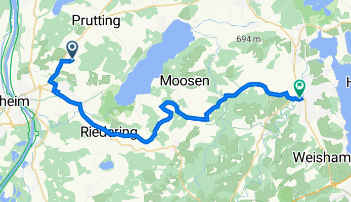
Högeringer Straße 50, Stephanskirchen nach Lujo-Brentano-Straße 1-3, Prien am Chiemsee
A cycling route starting in Stephanskirchen, Bavaria, Germany.
Overview
About this route
- 1 h 28 min
- Duration
- 20.9 km
- Distance
- 310 m
- Ascent
- 277 m
- Descent
- 14.2 km/h
- Avg. speed
- 588 m
- Max. altitude
Route quality
Waytypes & surfaces along the route
Waytypes
Quiet road
11.3 km
(54 %)
Path
4.4 km
(21 %)
Surfaces
Paved
19.2 km
(92 %)
Asphalt
19.1 km
(92 %)
Wood
0.1 km
(<1 %)
Undefined
1.6 km
(8 %)
Continue with Bikemap
Use, edit, or download this cycling route
You would like to ride Högeringer Straße 50, Stephanskirchen nach Lujo-Brentano-Straße 1-3, Prien am Chiemsee or customize it for your own trip? Here is what you can do with this Bikemap route:
Free features
- Save this route as favorite or in collections
- Copy & plan your own version of this route
- Sync your route with Garmin or Wahoo
Premium features
Free trial for 3 days, or one-time payment. More about Bikemap Premium.
- Navigate this route on iOS & Android
- Export a GPX / KML file of this route
- Create your custom printout (try it for free)
- Download this route for offline navigation
Discover more Premium features.
Get Bikemap PremiumFrom our community
Other popular routes starting in Stephanskirchen
 Simseerunde über Ratzingerhöhe
- Distance
- 27.8 km
- Ascent
- 337 m
- Descent
- 340 m
- Location
- Stephanskirchen, Bavaria, Germany
 2004 Salinenradweg Rosenheim bis Chiemsee
- Distance
- 25.3 km
- Ascent
- 319 m
- Descent
- 263 m
- Location
- Stephanskirchen, Bavaria, Germany
 Simssee/Bernau/Höhenmoos
- Distance
- 61.6 km
- Ascent
- 583 m
- Descent
- 531 m
- Location
- Stephanskirchen, Bavaria, Germany
 Prien/Aschau/Samerberg/Mühltal/Höhenmoos
- Distance
- 79.8 km
- Ascent
- 808 m
- Descent
- 810 m
- Location
- Stephanskirchen, Bavaria, Germany
 Samerberg/Mühltal/Prien
- Distance
- 62.8 km
- Ascent
- 711 m
- Descent
- 717 m
- Location
- Stephanskirchen, Bavaria, Germany
 Feierabendrunde: länger, aber flacher zur Dandlbergalm
- Distance
- 39 km
- Ascent
- 381 m
- Descent
- 399 m
- Location
- Stephanskirchen, Bavaria, Germany
 Aschaurunde
- Distance
- 68.6 km
- Ascent
- 786 m
- Descent
- 800 m
- Location
- Stephanskirchen, Bavaria, Germany
 Baierbach-Söllhuben-Raubling
- Distance
- 25.9 km
- Ascent
- 260 m
- Descent
- 224 m
- Location
- Stephanskirchen, Bavaria, Germany
Open it in the app