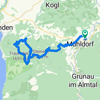
2023_06_26_Steineck
A cycling route starting in Scharnstein, Upper Austria, Austria.
Overview
About this route
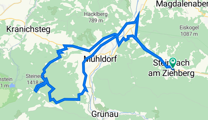
Von Forsthaus Schindlegg 500 HM aufs Steineck und Jacksonstein.
- -:--
- Duration
- 42.9 km
- Distance
- 1,219 m
- Ascent
- 1,220 m
- Descent
- ---
- Avg. speed
- 1,389 m
- Avg. speed
Route quality
Waytypes & surfaces along the route
Waytypes
Quiet road
15 km
(35 %)
Track
10 km
(23 %)
Surfaces
Paved
12.1 km
(28 %)
Unpaved
12.4 km
(29 %)
Asphalt
12.1 km
(28 %)
Gravel
8.3 km
(19 %)
Continue with Bikemap
Use, edit, or download this cycling route
You would like to ride 2023_06_26_Steineck or customize it for your own trip? Here is what you can do with this Bikemap route:
Free features
- Save this route as favorite or in collections
- Copy & plan your own version of this route
- Sync your route with Garmin or Wahoo
Premium features
Free trial for 3 days, or one-time payment. More about Bikemap Premium.
- Navigate this route on iOS & Android
- Export a GPX / KML file of this route
- Create your custom printout (try it for free)
- Download this route for offline navigation
Discover more Premium features.
Get Bikemap PremiumFrom our community
Other popular routes starting in Scharnstein
- 2025_05_27_Steinbach-Laudachsee
- Distance
- 49.2 km
- Ascent
- 1,293 m
- Descent
- 1,294 m
- Location
- Scharnstein, Upper Austria, Austria
- von Scharnstein ins Almtal
- Distance
- 58.5 km
- Ascent
- 347 m
- Descent
- 353 m
- Location
- Scharnstein, Upper Austria, Austria
- laudachsee
- Distance
- 38.6 km
- Ascent
- 1,543 m
- Descent
- 1,544 m
- Location
- Scharnstein, Upper Austria, Austria
- Einfache Fahrt in Vorchdorf
- Distance
- 18.5 km
- Ascent
- 138 m
- Descent
- 194 m
- Location
- Scharnstein, Upper Austria, Austria
- OBK Schobermühle (Hendl) Scharnstein
- Distance
- 4.2 km
- Ascent
- 93 m
- Descent
- 25 m
- Location
- Scharnstein, Upper Austria, Austria
- 2025_Viechtwang-Weyregg
- Distance
- 43.1 km
- Ascent
- 1,084 m
- Descent
- 1,107 m
- Location
- Scharnstein, Upper Austria, Austria
- 2025_Viechtwang-Almsee
- Distance
- 59 km
- Ascent
- 1,039 m
- Descent
- 1,038 m
- Location
- Scharnstein, Upper Austria, Austria
- Mühldorf nach Grünau im Altal
- Distance
- 20.7 km
- Ascent
- 266 m
- Descent
- 211 m
- Location
- Scharnstein, Upper Austria, Austria
Open it in the app