
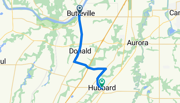
Butte Street Northeast 10767, Aurora to D Street 2600, Hubbard
A cycling route starting in Wilsonville, Oregon, United States.
Overview
About this route
- 53 min
- Duration
- 12.6 km
- Distance
- 98 m
- Ascent
- 64 m
- Descent
- 14.3 km/h
- Avg. speed
- 63 m
- Max. altitude

Route quality
Waytypes & surfaces along the route
Waytypes
Road
7.7 km
(61 %)
Busy road
4.9 km
(39 %)
Undefined
-0 km
(<1 %)
Surfaces
Paved
2.7 km
(21 %)
Concrete
2.7 km
(21 %)
Undefined
9.9 km
(79 %)
Continue with Bikemap
Use, edit, or download this cycling route
You would like to ride Butte Street Northeast 10767, Aurora to D Street 2600, Hubbard or customize it for your own trip? Here is what you can do with this Bikemap route:
Free features
- Save this route as favorite or in collections
- Copy & plan your own version of this route
- Sync your route with Garmin or Wahoo
Premium features
Free trial for 3 days, or one-time payment. More about Bikemap Premium.
- Navigate this route on iOS & Android
- Export a GPX / KML file of this route
- Create your custom printout (try it for free)
- Download this route for offline navigation
Discover more Premium features.
Get Bikemap PremiumFrom our community
Other popular routes starting in Wilsonville
 Wilsonville Climb
- Distance
- 26.4 km
- Ascent
- 410 m
- Descent
- 411 m
- Location
- Wilsonville, Oregon, United States
 8253 SW Wilsonville Rd, Wilsonville to 7262 SW Nevada Terr, Portland
- Distance
- 24.7 km
- Ascent
- 338 m
- Descent
- 269 m
- Location
- Wilsonville, Oregon, United States
 Slow ride in Wilsonville
- Distance
- 37 km
- Ascent
- 270 m
- Descent
- 262 m
- Location
- Wilsonville, Oregon, United States
 28704 SW Villebois Dr N, Wilsonville to 28708 SW Villebois Dr N, Wilsonville
- Distance
- 10 km
- Ascent
- 48 m
- Descent
- 60 m
- Location
- Wilsonville, Oregon, United States
 10767 Butte St NE, Aurora to 8239 Champoeg Rd NE, Saint Paul
- Distance
- 9.6 km
- Ascent
- 79 m
- Descent
- 75 m
- Location
- Wilsonville, Oregon, United States
 Northeast Prairie View Drive 25109, Aurora to Southwest Miley Road 8995, Wilsonville
- Distance
- 57.2 km
- Ascent
- 317 m
- Descent
- 314 m
- Location
- Wilsonville, Oregon, United States
 Buttesville store to Hubbard
- Distance
- 12.6 km
- Ascent
- 98 m
- Descent
- 64 m
- Location
- Wilsonville, Oregon, United States
 Southwest Wagner Street 28348, Wilsonville to Southwest Wagner Street 28348, Wilsonville
- Distance
- 11.8 km
- Ascent
- 187 m
- Descent
- 157 m
- Location
- Wilsonville, Oregon, United States
Open it in the app