

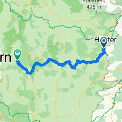
Godelheim - Ottbergen durchs Nethetal
A cycling route starting in Boffzen, Lower Saxony, Germany.
Overview
About this route
Early Sunday morning through the Nethe Valley and back
- 1 h 20 min
- Duration
- 20.5 km
- Distance
- 87 m
- Ascent
- 89 m
- Descent
- 15.4 km/h
- Avg. speed
- 129 m
- Max. altitude
Route quality
Waytypes & surfaces along the route
Waytypes
Track
8.6 km
(42 %)
Quiet road
4.1 km
(20 %)
Surfaces
Paved
17.2 km
(84 %)
Unpaved
0.8 km
(4 %)
Asphalt
15 km
(73 %)
Paved (undefined)
2.3 km
(11 %)
Continue with Bikemap
Use, edit, or download this cycling route
You would like to ride Godelheim - Ottbergen durchs Nethetal or customize it for your own trip? Here is what you can do with this Bikemap route:
Free features
- Save this route as favorite or in collections
- Copy & plan your own version of this route
- Sync your route with Garmin or Wahoo
Premium features
Free trial for 3 days, or one-time payment. More about Bikemap Premium.
- Navigate this route on iOS & Android
- Export a GPX / KML file of this route
- Create your custom printout (try it for free)
- Download this route for offline navigation
Discover more Premium features.
Get Bikemap PremiumFrom our community
Other popular routes starting in Boffzen
 Maygadessen - Höxter - Emmer Stausee - Bad Meinberg u. zurück
- Distance
- 111.6 km
- Ascent
- 470 m
- Descent
- 470 m
- Location
- Boffzen, Lower Saxony, Germany
 Boffzen - Holzminden - Boffzen
- Distance
- 28 km
- Ascent
- 92 m
- Descent
- 99 m
- Location
- Boffzen, Lower Saxony, Germany
 Godelheim Brakel
- Distance
- 46.4 km
- Ascent
- 142 m
- Descent
- 142 m
- Location
- Boffzen, Lower Saxony, Germany
 Maygadessen - Weserradweg - Beverungen - Amelunxen - Wellnessroute - Bad Driburg
- Distance
- 99.4 km
- Ascent
- 458 m
- Descent
- 467 m
- Location
- Boffzen, Lower Saxony, Germany
 Godelheimer Straße 55, Höxter nach Cheruskerstraße 25, Altenbeken
- Distance
- 47.8 km
- Ascent
- 437 m
- Descent
- 256 m
- Location
- Boffzen, Lower Saxony, Germany
 Godelheim - Ottbergen durchs Nethetal
- Distance
- 20.5 km
- Ascent
- 87 m
- Descent
- 89 m
- Location
- Boffzen, Lower Saxony, Germany
 Godelheim - Beverungen - Höxter
- Distance
- 32 km
- Ascent
- 180 m
- Descent
- 180 m
- Location
- Boffzen, Lower Saxony, Germany
 L549 1, Boffzen nach Zeppelinstraße 30, Holzminden
- Distance
- 12.7 km
- Ascent
- 48 m
- Descent
- 68 m
- Location
- Boffzen, Lower Saxony, Germany
Open it in the app