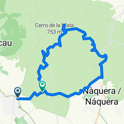
Manuel y Alejandro de Marines
A cycling route starting in Olocau, Valencia, Spain.
Overview
About this route
Siendo una ruta para aficionados tiene todos los ingredientes para la diversion por lo que se puede convertir en una peque帽a buena ruta... asfalto, camino hacia un rio seco siendo muy complicada la bajada por el desgaste del terreno, cuestas arriba, cuestas abajo a gran velocidad, esperamos que os guste.
- -:--
- Duration
- 9.4 km
- Distance
- 86 m
- Ascent
- 85 m
- Descent
- ---
- Avg. speed
- ---
- Avg. speed
Route quality
Waytypes & surfaces along the route
Waytypes
Undefined
9.4 km
(100 %)
Surfaces
Undefined
9.4 km
(100 %)
Route highlights
Points of interest along the route
Point of interest after 2 km
nos dirigimos hacia Olocau
Point of interest after 2.8 km
iniciamos ruta de asfalto por camino rural
Point of interest after 3.5 km
pendiente pronunciada donde se coge bastante velocidad
Point of interest after 4.1 km
curva muy pronunciada y cerrada a mucha velocidad
Point of interest after 4.2 km
mas curvas a gran velocidad, suerte que es asfaltado
Point of interest after 4.5 km
curva total a gran velocidad
Point of interest after 6 km
lo mas complicado ya que la bajada esta llena de surcos bastante notables por la erosi贸n del agua en direcci贸n al rio
Point of interest after 6.2 km
entramos en el rio
Point of interest after 6.4 km
salimos del r铆o y entramos en asfalto
Point of interest after 6.7 km
y ahora para mas de lo mas iniciamos cuesta arriba
Point of interest after 7.4 km
de vuelta a Marines por el mismo sitio, carril bici
Continue with Bikemap
Use, edit, or download this cycling route
You would like to ride Manuel y Alejandro de Marines or customize it for your own trip? Here is what you can do with this Bikemap route:
Free features
- Save this route as favorite or in collections
- Copy & plan your own version of this route
- Sync your route with Garmin or Wahoo
Premium features
Free trial for 3 days, or one-time payment. More about Bikemap Premium.
- Navigate this route on iOS & Android
- Export a GPX / KML file of this route
- Create your custom printout (try it for free)
- Download this route for offline navigation
Discover more Premium features.
Get Bikemap PremiumFrom our community
Other popular routes starting in Olocau
- Olocau - Puntal del Llop - Gatova - Olocau CLONED FROM ROUTE 767221
- Distance
- 44.3 km
- Ascent
- 797 m
- Descent
- 793 m
- Location
- Olocau, Valencia, Spain
- Olocau - Gatova
- Distance
- 26.1 km
- Ascent
- 630 m
- Descent
- 636 m
- Location
- Olocau, Valencia, Spain
- Volteta por PortaCoeli 2.0 Calderona IBP46
- Distance
- 27 km
- Ascent
- 409 m
- Descent
- 409 m
- Location
- Olocau, Valencia, Spain
- Olocau-Cerro del lobo
- Distance
- 48.5 km
- Ascent
- 673 m
- Descent
- 674 m
- Location
- Olocau, Valencia, Spain
- Gasolinera Olocau ,Serra y vuelta
- Distance
- 29.9 km
- Ascent
- 1,392 m
- Descent
- 1,306 m
- Location
- Olocau, Valencia, Spain
- Senda Font Gota-Berro-Poll-Trist谩n
- Distance
- 32.6 km
- Ascent
- 657 m
- Descent
- 657 m
- Location
- Olocau, Valencia, Spain
- Pico Aguila
- Distance
- 16.2 km
- Ascent
- 551 m
- Descent
- 160 m
- Location
- Olocau, Valencia, Spain
- Manuel y Alejandro de Marines
- Distance
- 9.4 km
- Ascent
- 86 m
- Descent
- 85 m
- Location
- Olocau, Valencia, Spain