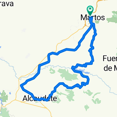
Venta El Papero,Sierra Grande,Villarbajo,rizo en Alcaudete,v. verde,Martos.
- 75.2 km
- 1,392 m
- 1,409 m
- Martos, Andalusia, Spain
A cycling route starting in Martos, Andalusia, Spain.
Overview
We left Martos and entered the greenway via the Velda road, we exited at the height of Venta Pantalones to enter the path of the Sierra, in its last meters we turned right again to continue crossing the Sierra. This time we ended up descending the slope of the pines to join the Alcaudete road via Villarbajo. We crowned this pass, descended to Alcaudete, turned left and climbed to the observatory of Sierra Ahillos via Fuenteamuña. Again we retraced our steps and took the road from Villarbajo towards the Viboras reservoir, but this time, at the height of the hermitage of the Virgin of Fatima, we turned right to begin climbing a very steep and winding local road that would take us to the area of the village of Hoyo Piedra. At the crossroads, we turned left to begin descending toward Los Llanillos and Las Veletas, we continued until the intersection with the Fuensanta road, turned left and followed back to Martos. Long-distance route with many changes in the type of surface as well as in landscapes, quite demanding, with downhill and steep uphill sections. This route traverses a large part of our area and also passes through regions of Alcaudete, Castillo de Locubín and Fuensanta. Recommended for cyclists with a high physical level since the route is quite demanding; we could compare it to one of the marathons we run throughout the year.
created this 14 years ago
Continue with Bikemap
You would like to ride sierra de las casillas,observ. Ahillos,hoyo piedra,fuensanta,martos or customize it for your own trip? Here is what you can do with this Bikemap route:
Free trial for 3 days, or one-time payment. More about Bikemap Premium.
Discover more Premium features.
Get Bikemap PremiumFrom our community
Open it in the app