
Sierra Ahillos por fuente amuña,presa viboras,Martos por el Alamillo
A cycling route starting in Martos, Andalusia, Spain.
Overview
About this route
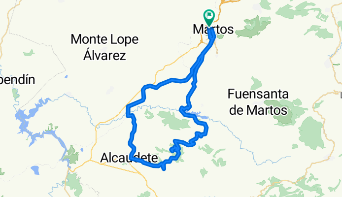
We leave Martos and join the greenway along the path to Velda, after passing the viaduct of the viboras we turn left onto the path of Fuente Amoña, continue along this to Alcaudete, there we turn right and look for the road to Villarbajo, we head towards Fuente Amoña, begin to climb towards the observatory of Sierra Ahillos, reach the summit and return on our steps, we join the road to Alcaudete via Villarbajo, descend to the dam, take the national road to Alcaudete Martos, turn right to pass through the cortijo del Alamillo, cross the stream and ascend until we reach Martos. This route has everything, greenways, tracks, trails, there are steep climbs and descents, recommended for cyclists with medium to high level, it runs through beautiful scenery where we can find traditional olive groves, Mediterranean forest and where we can observe a large number of birds and animals.
- -:--
- Duration
- 59.9 km
- Distance
- 1,226 m
- Ascent
- 1,226 m
- Descent
- ---
- Avg. speed
- ---
- Max. altitude

Continue with Bikemap
Use, edit, or download this cycling route
You would like to ride Sierra Ahillos por fuente amuña,presa viboras,Martos por el Alamillo or customize it for your own trip? Here is what you can do with this Bikemap route:
Free features
- Save this route as favorite or in collections
- Copy & plan your own version of this route
- Sync your route with Garmin or Wahoo
Premium features
Free trial for 3 days, or one-time payment. More about Bikemap Premium.
- Navigate this route on iOS & Android
- Export a GPX / KML file of this route
- Create your custom printout (try it for free)
- Download this route for offline navigation
Discover more Premium features.
Get Bikemap PremiumFrom our community
Other popular routes starting in Martos
 Via verde,7 curvas,la cabra,mirador,neberal,f. el palo,v. verde,Martos
- Distance
- 52.3 km
- Ascent
- 821 m
- Descent
- 822 m
- Location
- Martos, Andalusia, Spain
 Venta El Papero,Sierra Grande,Villarbajo,rizo en Alcaudete,v. verde,Martos.
- Distance
- 75.2 km
- Ascent
- 1,392 m
- Descent
- 1,409 m
- Location
- Martos, Andalusia, Spain
 Alcaudete por Venta Pantalones,cortijo El Portillo,presa del Viboras,Casillas;Carrasca,Martos,Monte Lope,Martos
- Distance
- 86.5 km
- Ascent
- 1,294 m
- Descent
- 1,298 m
- Location
- Martos, Andalusia, Spain
 Venta el papero,Fuente el espino,presa Viboras,Martos
- Distance
- 43.8 km
- Ascent
- 894 m
- Descent
- 873 m
- Location
- Martos, Andalusia, Spain
 Camino del Moro,La Grana,Marchante,Cresta,Jamilena,Via verde,Martos
- Distance
- 29.8 km
- Ascent
- 731 m
- Descent
- 733 m
- Location
- Martos, Andalusia, Spain
 El Madroño,El Coracho,Las Peñuelas,Las Aceras,Lendinez,Martos
- Distance
- 43.9 km
- Ascent
- 557 m
- Descent
- 557 m
- Location
- Martos, Andalusia, Spain
 LasCHORRERAS
- Distance
- 65.2 km
- Ascent
- 1,224 m
- Descent
- 1,223 m
- Location
- Martos, Andalusia, Spain
 SIERRA SUR de JAÉN
- Distance
- 89.9 km
- Ascent
- 1,342 m
- Descent
- 1,352 m
- Location
- Martos, Andalusia, Spain
Open it in the app