Wheaton to Rockville
A cycling route starting in Wheaton, Maryland, United States of America.
Overview
About this route
Great ride.
Rock Creek Trail North then Baltimore Road towards Rockville which was a challenging but not unbearable climb. Round trip 24 miles.
Cut out Sotuh Kensington on way home.
- -:--
- Duration
- 38.4 km
- Distance
- 258 m
- Ascent
- 259 m
- Descent
- ---
- Avg. speed
- ---
- Avg. speed
Continue with Bikemap
Use, edit, or download this cycling route
You would like to ride Wheaton to Rockville or customize it for your own trip? Here is what you can do with this Bikemap route:
Free features
- Save this route as favorite or in collections
- Copy & plan your own version of this route
- Sync your route with Garmin or Wahoo
Premium features
Free trial for 3 days, or one-time payment. More about Bikemap Premium.
- Navigate this route on iOS & Android
- Export a GPX / KML file of this route
- Create your custom printout (try it for free)
- Download this route for offline navigation
Discover more Premium features.
Get Bikemap PremiumFrom our community
Other popular routes starting in Wheaton
- Bethesda Trolley loop
- Distance
- 23 km
- Ascent
- 205 m
- Descent
- 204 m
- Location
- Wheaton, Maryland, United States of America
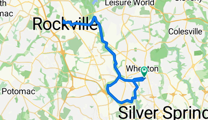
- bike tour from Silver Spring to Washington
- Distance
- 18.1 km
- Ascent
- 103 m
- Descent
- 160 m
- Location
- Wheaton, Maryland, United States of America
- Rock Creek to Matthew Henson trail
- Distance
- 21.4 km
- Ascent
- 207 m
- Descent
- 204 m
- Location
- Wheaton, Maryland, United States of America
- Wheaton to hanes Point
- Distance
- 35.6 km
- Ascent
- 145 m
- Descent
- 255 m
- Location
- Wheaton, Maryland, United States of America
- Wheaton to Friendship Heights
- Distance
- 24.8 km
- Ascent
- 249 m
- Descent
- 249 m
- Location
- Wheaton, Maryland, United States of America
- Wheaton to Bethesda and back
- Distance
- 17.3 km
- Ascent
- 186 m
- Descent
- 185 m
- Location
- Wheaton, Maryland, United States of America
- Wheaton to Olney
- Distance
- 48.9 km
- Ascent
- 246 m
- Descent
- 247 m
- Location
- Wheaton, Maryland, United States of America
- Sligo Creek to Rock Creek via Takoma
- Distance
- 25.8 km
- Ascent
- 197 m
- Descent
- 197 m
- Location
- Wheaton, Maryland, United States of America
Open it in the app