

Kyselica - Gabčíkovo a späť
A cycling route starting in Šamorín, Trnavský kraj, Slovak Republic.
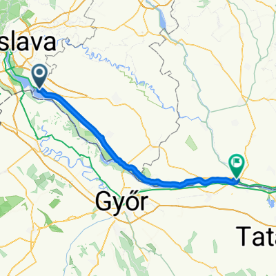
Overview
About this route
Rovinatá cyklotúra okolo vodného diela Gabčíkovo, začiatok aj koniec pri kompe v Kyselici. Trasa vedie čiastočne hrádzou vodného diela, čiastočne lužnými lesmi okolo pôvodných dunajských ramien. Povrch spevnený, vhodný na trekové a horské bicykle.
- -:--
- Duration
- 53.7 km
- Distance
- 72 m
- Ascent
- 72 m
- Descent
- ---
- Avg. speed
- ---
- Avg. speed

Continue with Bikemap
Use, edit, or download this cycling route
You would like to ride Kyselica - Gabčíkovo a späť or customize it for your own trip? Here is what you can do with this Bikemap route:
Free features
- Save this route as favorite or in collections
- Copy & plan your own version of this route
- Sync your route with Garmin or Wahoo
Premium features
Free trial for 3 days, or one-time payment. More about Bikemap Premium.
- Navigate this route on iOS & Android
- Export a GPX / KML file of this route
- Create your custom printout (try it for free)
- Download this route for offline navigation
Discover more Premium features.
Get Bikemap PremiumFrom our community
Other popular routes starting in Šamorín
 Kyselica - Gabčíkovo a späť
- Distance
- 53.7 km
- Ascent
- 72 m
- Descent
- 72 m
- Location
- Šamorín, Trnavský kraj, Slovak Republic
 a Duna víztározó körül 2015.04.19.
- Distance
- 100 km
- Ascent
- 61 m
- Descent
- 61 m
- Location
- Šamorín, Trnavský kraj, Slovak Republic
 Day 2 - Šamorín - Komárno
- Distance
- 80.4 km
- Ascent
- 75 m
- Descent
- 88 m
- Location
- Šamorín, Trnavský kraj, Slovak Republic
 najvacsi chill-smrt
- Distance
- 58.9 km
- Ascent
- 45 m
- Descent
- 48 m
- Location
- Šamorín, Trnavský kraj, Slovak Republic
 R: Okolo Hrušovskej zdrže a cez kompu (Kyselica - Prístavný most)
- Distance
- 62.6 km
- Ascent
- 29 m
- Descent
- 26 m
- Location
- Šamorín, Trnavský kraj, Slovak Republic
 Burgenland
- Distance
- 225.1 km
- Ascent
- 268 m
- Descent
- 270 m
- Location
- Šamorín, Trnavský kraj, Slovak Republic
 2. Čuňovo - Köszek_112km
- Distance
- 111.7 km
- Ascent
- 231 m
- Descent
- 89 m
- Location
- Šamorín, Trnavský kraj, Slovak Republic
 Čilistov X-BIONIC SPHERE-Kyselica-Horný Bar-Gabčíkovo-Čilistov X-BIONIC SPHERE
- Distance
- 50.8 km
- Ascent
- 33 m
- Descent
- 33 m
- Location
- Šamorín, Trnavský kraj, Slovak Republic
Open it in the app