

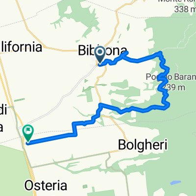
Tour vom 30.07.2009
A cycling route starting in Bibbona, Tuscany, Italy.
Overview
About this route
- -:--
- Duration
- 112.7 km
- Distance
- 2,165 m
- Ascent
- 2,205 m
- Descent
- ---
- Avg. speed
- 531 m
- Max. altitude
Route quality
Waytypes & surfaces along the route
Waytypes
Road
23.7 km
(21 %)
Quiet road
4.5 km
(4 %)
Surfaces
Paved
98 km
(87 %)
Unpaved
4.5 km
(4 %)
Asphalt
98 km
(87 %)
Gravel
3.4 km
(3 %)
Continue with Bikemap
Use, edit, or download this cycling route
You would like to ride Tour vom 30.07.2009 or customize it for your own trip? Here is what you can do with this Bikemap route:
Free features
- Save this route as favorite or in collections
- Copy & plan your own version of this route
- Split it into stages to create a multi-day tour
- Sync your route with Garmin or Wahoo
Premium features
Free trial for 3 days, or one-time payment. More about Bikemap Premium.
- Navigate this route on iOS & Android
- Export a GPX / KML file of this route
- Create your custom printout (try it for free)
- Download this route for offline navigation
Discover more Premium features.
Get Bikemap PremiumFrom our community
Other popular routes starting in Bibbona
 Piazza delle Querce, Bibbona nach Strada Comunale delle Sondraie, Castagneto Carducci
- Distance
- 14.4 km
- Ascent
- 248 m
- Descent
- 313 m
- Location
- Bibbona, Tuscany, Italy
 Von Bibbona Etappe 1
- Distance
- 15 km
- Ascent
- 271 m
- Descent
- 332 m
- Location
- Bibbona, Tuscany, Italy
 Tour vom 30.07.2009
- Distance
- 112.7 km
- Ascent
- 2,165 m
- Descent
- 2,205 m
- Location
- Bibbona, Tuscany, Italy
 Bibbona - Pomerance - Monteverdi - Bibbona
- Distance
- 107.6 km
- Ascent
- 2,398 m
- Descent
- 2,385 m
- Location
- Bibbona, Tuscany, Italy
 Bibbona to Portoferraio
- Distance
- 86.6 km
- Ascent
- 519 m
- Descent
- 575 m
- Location
- Bibbona, Tuscany, Italy
 Steady ride in tuscany
- Distance
- 12.9 km
- Ascent
- 35 m
- Descent
- 75 m
- Location
- Bibbona, Tuscany, Italy
 bolgheri punta ala
- Distance
- 83.9 km
- Ascent
- 885 m
- Descent
- 940 m
- Location
- Bibbona, Tuscany, Italy
 Piazza Teresa 3, Bolgheri nach Unnamed Road, Bibbona
- Distance
- 10.4 km
- Ascent
- 5 m
- Descent
- 46 m
- Location
- Bibbona, Tuscany, Italy
Open it in the app