
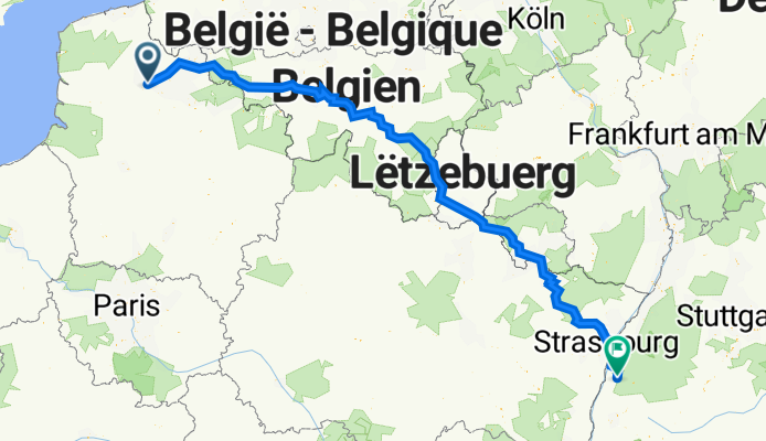
Allée Champêtre 20, Hesdigneul-lès-Béthune to Turmstraße 29, Lahr/Schwarzwald
A cycling route starting in Gosnay, Hauts-de-France, France.
Overview
About this route
- 33 h 49 min
- Duration
- 653.1 km
- Distance
- 6,555 m
- Ascent
- 6,428 m
- Descent
- 19.3 km/h
- Avg. speed
- 550 m
- Max. altitude

Route quality
Waytypes & surfaces along the route
Waytypes
Road
169.8 km
(26 %)
Cycleway
169.8 km
(26 %)
Surfaces
Paved
457.2 km
(70 %)
Asphalt
391.9 km
(60 %)
Concrete
39.2 km
(6 %)
Continue with Bikemap
Use, edit, or download this cycling route
You would like to ride Allée Champêtre 20, Hesdigneul-lès-Béthune to Turmstraße 29, Lahr/Schwarzwald or customize it for your own trip? Here is what you can do with this Bikemap route:
Free features
- Save this route as favorite or in collections
- Copy & plan your own version of this route
- Split it into stages to create a multi-day tour
- Sync your route with Garmin or Wahoo
Premium features
Free trial for 3 days, or one-time payment. More about Bikemap Premium.
- Navigate this route on iOS & Android
- Export a GPX / KML file of this route
- Create your custom printout (try it for free)
- Download this route for offline navigation
Discover more Premium features.
Get Bikemap PremiumFrom our community
Other popular routes starting in Gosnay
 gravel bruay
- Distance
- 60.8 km
- Ascent
- 437 m
- Descent
- 437 m
- Location
- Gosnay, Hauts-de-France, France
 Allée Champêtre 20, Hesdigneul-lès-Béthune to D339, Beaufort-Blavincourt
- Distance
- 32.6 km
- Ascent
- 296 m
- Descent
- 204 m
- Location
- Gosnay, Hauts-de-France, France
 Allée Champêtre 20, Hesdigneul-lès-Béthune to Turmstraße 29, Lahr/Schwarzwald
- Distance
- 653.1 km
- Ascent
- 6,555 m
- Descent
- 6,428 m
- Location
- Gosnay, Hauts-de-France, France
 BVCC Bethune to Ghent
- Distance
- 111.5 km
- Ascent
- 65 m
- Descent
- 81 m
- Location
- Gosnay, Hauts-de-France, France
 shelt FN
- Distance
- 578.9 km
- Ascent
- 1,101 m
- Descent
- 1,132 m
- Location
- Gosnay, Hauts-de-France, France
 De Bruay-la-Buissière à Chemin de Lilliers, Divion
- Distance
- 6.5 km
- Ascent
- 41 m
- Descent
- 41 m
- Location
- Gosnay, Hauts-de-France, France
 short around fr
- Distance
- 2,616.2 km
- Ascent
- 5,863 m
- Descent
- 5,862 m
- Location
- Gosnay, Hauts-de-France, France
 Allée Champêtre 14, Hesdigneul-lès-Béthune to Rue du Chemin des Dames 1987, Bruay-la-Buissière
- Distance
- 34.6 km
- Ascent
- 354 m
- Descent
- 369 m
- Location
- Gosnay, Hauts-de-France, France
Open it in the app