

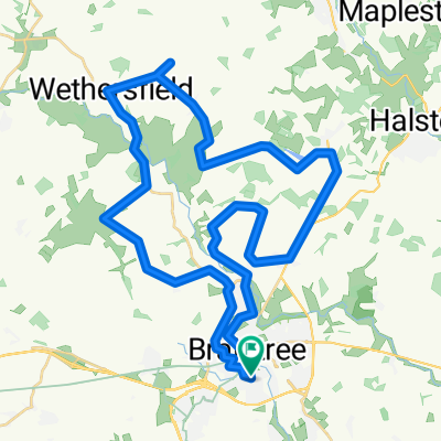
Braintree to Airport view and back
A cycling route starting in Braintree, England, United Kingdom.
Overview
About this route
- -:--
- Duration
- 52.7 km
- Distance
- 290 m
- Ascent
- 292 m
- Descent
- ---
- Avg. speed
- 112 m
- Max. altitude

Route quality
Waytypes & surfaces along the route
Waytypes
Road
18.4 km
(35 %)
Cycleway
16.9 km
(32 %)
Surfaces
Paved
7.9 km
(15 %)
Unpaved
15.3 km
(29 %)
Gravel
13.2 km
(25 %)
Asphalt
4.7 km
(9 %)
Continue with Bikemap
Use, edit, or download this cycling route
You would like to ride Braintree to Airport view and back or customize it for your own trip? Here is what you can do with this Bikemap route:
Free features
- Save this route as favorite or in collections
- Copy & plan your own version of this route
- Sync your route with Garmin or Wahoo
Premium features
Free trial for 3 days, or one-time payment. More about Bikemap Premium.
- Navigate this route on iOS & Android
- Export a GPX / KML file of this route
- Create your custom printout (try it for free)
- Download this route for offline navigation
Discover more Premium features.
Get Bikemap PremiumFrom our community
Other popular routes starting in Braintree
 Lengthy bike tour through Braintree
- Distance
- 42.9 km
- Ascent
- 176 m
- Descent
- 176 m
- Location
- Braintree, England, United Kingdom
 6 Woods
- Distance
- 19.7 km
- Ascent
- 129 m
- Descent
- 131 m
- Location
- Braintree, England, United Kingdom
 Porters Field 53 to Porters Field 53
- Distance
- 16.7 km
- Ascent
- 128 m
- Descent
- 128 m
- Location
- Braintree, England, United Kingdom
 Train station Maldon East and Heybridge railway station by bike
- Distance
- 79.1 km
- Ascent
- 449 m
- Descent
- 449 m
- Location
- Braintree, England, United Kingdom
 Braintree, Maldon
- Distance
- 65 km
- Ascent
- 263 m
- Descent
- 265 m
- Location
- Braintree, England, United Kingdom
 100 miler
- Distance
- 167.9 km
- Ascent
- 451 m
- Descent
- 449 m
- Location
- Braintree, England, United Kingdom
 Braintree-Wethersfield-Braintree
- Distance
- 31.5 km
- Ascent
- 133 m
- Descent
- 131 m
- Location
- Braintree, England, United Kingdom
 Braintree to Airport view and back
- Distance
- 52.7 km
- Ascent
- 290 m
- Descent
- 292 m
- Location
- Braintree, England, United Kingdom
Open it in the app