

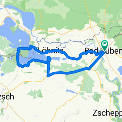
Bad Düben - Bad Schmiedeberg Lausiger Teich
A cycling route starting in Bad Düben, Saxony, Germany.
Overview
About this route
- 1 h 53 min
- Duration
- 26.7 km
- Distance
- 207 m
- Ascent
- 207 m
- Descent
- 14.2 km/h
- Avg. speed
- 151 m
- Max. altitude

Route photos


Continue with Bikemap
Use, edit, or download this cycling route
You would like to ride Bad Düben - Bad Schmiedeberg Lausiger Teich or customize it for your own trip? Here is what you can do with this Bikemap route:
Free features
- Save this route as favorite or in collections
- Copy & plan your own version of this route
- Sync your route with Garmin or Wahoo
Premium features
Free trial for 3 days, or one-time payment. More about Bikemap Premium.
- Navigate this route on iOS & Android
- Export a GPX / KML file of this route
- Create your custom printout (try it for free)
- Download this route for offline navigation
Discover more Premium features.
Get Bikemap PremiumFrom our community
Other popular routes starting in Bad Düben
 Bad Düben Labrun
- Distance
- 38.3 km
- Ascent
- 149 m
- Descent
- 170 m
- Location
- Bad Düben, Saxony, Germany
 Bad Düben - Seelhausener See und zurück
- Distance
- 39.9 km
- Ascent
- 58 m
- Descent
- 58 m
- Location
- Bad Düben, Saxony, Germany
 3 Stunden Tour Dübener Heide
- Distance
- 94.7 km
- Ascent
- 365 m
- Descent
- 324 m
- Location
- Bad Düben, Saxony, Germany
 Düben-Torgau-Domitsch-Kemberg-Düben
- Distance
- 109.9 km
- Ascent
- 223 m
- Descent
- 223 m
- Location
- Bad Düben, Saxony, Germany
 Muldestausee -_ Bitterfeld am 6.Mai
- Distance
- 46.1 km
- Ascent
- 144 m
- Descent
- 136 m
- Location
- Bad Düben, Saxony, Germany
 Bad Düben / Mulderadweg
- Distance
- 37.2 km
- Ascent
- 36 m
- Descent
- 39 m
- Location
- Bad Düben, Saxony, Germany
 Bad Schmiedeberg am 8. Mai
- Distance
- 36.4 km
- Ascent
- 232 m
- Descent
- 231 m
- Location
- Bad Düben, Saxony, Germany
 Schwemsal_Bad Düben am 5.Mai
- Distance
- 26.3 km
- Ascent
- 67 m
- Descent
- 69 m
- Location
- Bad Düben, Saxony, Germany
Open it in the app