

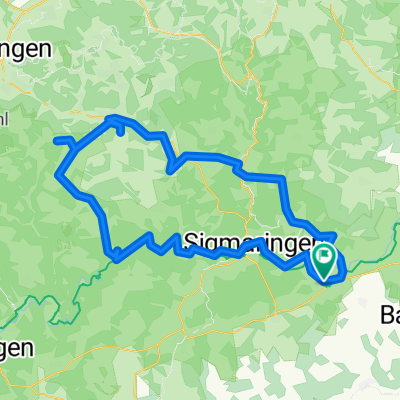
Overview
About this route
- -:--
- Duration
- 51.5 km
- Distance
- 281 m
- Ascent
- 342 m
- Descent
- ---
- Avg. speed
- 566 m
- Max. altitude

Part of
Radtour 2023
12 stages
Route quality
Waytypes & surfaces along the route
Waytypes
Track
21.2 km
(41 %)
Quiet road
13.7 km
(27 %)
Surfaces
Paved
39.4 km
(77 %)
Unpaved
4.7 km
(9 %)
Asphalt
38.7 km
(75 %)
Loose gravel
3.6 km
(7 %)
Continue with Bikemap
Use, edit, or download this cycling route
You would like to ride Radtour 2023 - 5. Tag or customize it for your own trip? Here is what you can do with this Bikemap route:
Free features
- Save this route as favorite or in collections
- Copy & plan your own version of this route
- Sync your route with Garmin or Wahoo
Premium features
Free trial for 3 days, or one-time payment. More about Bikemap Premium.
- Navigate this route on iOS & Android
- Export a GPX / KML file of this route
- Create your custom printout (try it for free)
- Download this route for offline navigation
Discover more Premium features.
Get Bikemap PremiumFrom our community
Other popular routes starting in Ennetach
 Rundfahrt Ennetach - Baggersee Zielfingen
- Distance
- 15.8 km
- Ascent
- 44 m
- Descent
- 89 m
- Location
- Ennetach, Baden-Wurttemberg, Germany
 Donauradweg Mengen-Blaubeuren CLONED FROM ROUTE 509819
- Distance
- 80.8 km
- Ascent
- 166 m
- Descent
- 207 m
- Location
- Ennetach, Baden-Wurttemberg, Germany
 BodenUmfahrung03
- Distance
- 245.5 km
- Ascent
- 674 m
- Descent
- 675 m
- Location
- Ennetach, Baden-Wurttemberg, Germany
 Rund Um Mengen
- Distance
- 30 km
- Ascent
- 198 m
- Descent
- 196 m
- Location
- Ennetach, Baden-Wurttemberg, Germany
 Donautal Alb Tour
- Distance
- 117.2 km
- Ascent
- 1,505 m
- Descent
- 1,414 m
- Location
- Ennetach, Baden-Wurttemberg, Germany
 E4.1. 8.7.25 Mengen nach Ulm
- Distance
- 44.1 km
- Ascent
- 153 m
- Descent
- 250 m
- Location
- Ennetach, Baden-Wurttemberg, Germany
 Samstags
- Distance
- 25.4 km
- Ascent
- 54 m
- Descent
- 54 m
- Location
- Ennetach, Baden-Wurttemberg, Germany
 Drummer5670
- Distance
- 28.1 km
- Ascent
- 228 m
- Descent
- 228 m
- Location
- Ennetach, Baden-Wurttemberg, Germany
Open it in the app