

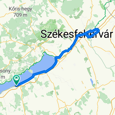
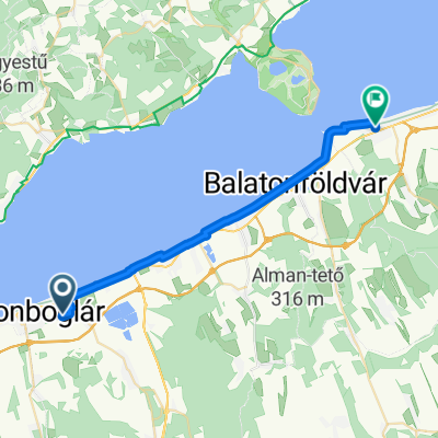
Móló sétány 3., Balatonlelle to Vásár tér 12., Keszthely
A cycling route starting in Balatonlelle, Somogy County, Hungary.
Overview
About this route
- 3 h 43 min
- Duration
- 48.4 km
- Distance
- 152 m
- Ascent
- 140 m
- Descent
- 13 km/h
- Avg. speed
- 124 m
- Max. altitude

Route quality
Waytypes & surfaces along the route
Waytypes
Living street
21.8 km
(45 %)
Cycleway
18.4 km
(38 %)
Surfaces
Paved
47.5 km
(98 %)
Asphalt
47.5 km
(98 %)
Undefined
1 km
(2 %)
Continue with Bikemap
Use, edit, or download this cycling route
You would like to ride Móló sétány 3., Balatonlelle to Vásár tér 12., Keszthely or customize it for your own trip? Here is what you can do with this Bikemap route:
Free features
- Save this route as favorite or in collections
- Copy & plan your own version of this route
- Sync your route with Garmin or Wahoo
Premium features
Free trial for 3 days, or one-time payment. More about Bikemap Premium.
- Navigate this route on iOS & Android
- Export a GPX / KML file of this route
- Create your custom printout (try it for free)
- Download this route for offline navigation
Discover more Premium features.
Get Bikemap PremiumFrom our community
Other popular routes starting in Balatonlelle
 Móló sétány 3., Balatonlelle to Vásár tér 12., Keszthely
- Distance
- 48.4 km
- Ascent
- 152 m
- Descent
- 140 m
- Location
- Balatonlelle, Somogy County, Hungary
 Balaton körbetekeres
- Distance
- 209.2 km
- Ascent
- 392 m
- Descent
- 396 m
- Location
- Balatonlelle, Somogy County, Hungary
 Balatonlelle - Velencei-tókör - Balatonlelle
- Distance
- 220.3 km
- Ascent
- 796 m
- Descent
- 796 m
- Location
- Balatonlelle, Somogy County, Hungary
 Dél-Balaton 1 napos (Pócz)
- Distance
- 48.4 km
- Ascent
- 183 m
- Descent
- 178 m
- Location
- Balatonlelle, Somogy County, Hungary
 hazaút - Petőfi utca - Szabadság tér
- Distance
- 25.7 km
- Ascent
- 50 m
- Descent
- 52 m
- Location
- Balatonlelle, Somogy County, Hungary
 Erdősor utca, Balatonlelle - 71-es főút, Szigliget
- Distance
- 64.2 km
- Ascent
- 305 m
- Descent
- 309 m
- Location
- Balatonlelle, Somogy County, Hungary
 somogyi dombok
- Distance
- 74.7 km
- Ascent
- 368 m
- Descent
- 365 m
- Location
- Balatonlelle, Somogy County, Hungary
 Római út, Balatonlelle - Balatonlelle
- Distance
- 6.4 km
- Ascent
- 216 m
- Descent
- 79 m
- Location
- Balatonlelle, Somogy County, Hungary
Open it in the app