

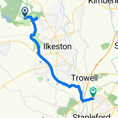
55–57 Pit Lane, Ilkeston to 201 Pasture Road, Nottingham
A cycling route starting in West Hallam, England, United Kingdom.
Overview
About this route
- 50 min
- Duration
- 9.8 km
- Distance
- 105 m
- Ascent
- 129 m
- Descent
- 11.7 km/h
- Avg. speed
- 84 m
- Max. altitude
Route quality
Waytypes & surfaces along the route
Waytypes
Cycleway
9.1 km
(92 %)
Road
0.5 km
(5 %)
Surfaces
Paved
7.7 km
(78 %)
Unpaved
1.5 km
(15 %)
Asphalt
7.7 km
(78 %)
Gravel
1 km
(11 %)
Continue with Bikemap
Use, edit, or download this cycling route
You would like to ride 55–57 Pit Lane, Ilkeston to 201 Pasture Road, Nottingham or customize it for your own trip? Here is what you can do with this Bikemap route:
Free features
- Save this route as favorite or in collections
- Copy & plan your own version of this route
- Sync your route with Garmin or Wahoo
Premium features
Free trial for 3 days, or one-time payment. More about Bikemap Premium.
- Navigate this route on iOS & Android
- Export a GPX / KML file of this route
- Create your custom printout (try it for free)
- Download this route for offline navigation
Discover more Premium features.
Get Bikemap PremiumFrom our community
Other popular routes starting in West Hallam
 Coronation Road 66, Stanley to Wilders Way
- Distance
- 21.6 km
- Ascent
- 164 m
- Descent
- 175 m
- Location
- West Hallam, England, United Kingdom
 Belper Road, Ilkeston to Old Pit Lane, Heanor
- Distance
- 32.3 km
- Ascent
- 437 m
- Descent
- 470 m
- Location
- West Hallam, England, United Kingdom
 Barley Barn, No Man's Lane, Ilkeston to Hopwell Lodge, Nottingham Road, Derby
- Distance
- 3.4 km
- Ascent
- 42 m
- Descent
- 80 m
- Location
- West Hallam, England, United Kingdom
 Lockdown route 1
- Distance
- 25.3 km
- Ascent
- 145 m
- Descent
- 171 m
- Location
- West Hallam, England, United Kingdom
 afternoon walk round West Hallam
- Distance
- 5.2 km
- Ascent
- 64 m
- Descent
- 64 m
- Location
- West Hallam, England, United Kingdom
 2023SportiveLongFinal - 2023SportiveLongFinal
- Distance
- 120 km
- Ascent
- 2,277 m
- Descent
- 2,282 m
- Location
- West Hallam, England, United Kingdom
 Foxholes Farm, Spondon Road, Ilkeston to 66 Appledore Ave, Nottingham
- Distance
- 12.6 km
- Ascent
- 83 m
- Descent
- 105 m
- Location
- West Hallam, England, United Kingdom
 55–57 Pit Lane, Ilkeston to 201 Pasture Road, Nottingham
- Distance
- 9.8 km
- Ascent
- 105 m
- Descent
- 129 m
- Location
- West Hallam, England, United Kingdom
Open it in the app