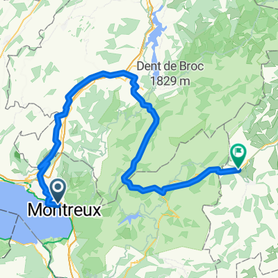
De Route des Colondalles 36, Montreux Ă Rue du Lac 128A, Montreux
A cycling route starting in Le Châtelard, Canton of Vaud, Switzerland.
Overview
About this route
- 7 min
- Duration
- 2.6 km
- Distance
- 34 m
- Ascent
- 0 m
- Descent
- 23.1 km/h
- Avg. speed
- 460 m
- Avg. speed
Continue with Bikemap
Use, edit, or download this cycling route
You would like to ride De Route des Colondalles 36, Montreux Ă Rue du Lac 128A, Montreux or customize it for your own trip? Here is what you can do with this Bikemap route:
Free features
- Save this route as favorite or in collections
- Copy & plan your own version of this route
- Sync your route with Garmin or Wahoo
Premium features
Free trial for 3 days, or one-time payment. More about Bikemap Premium.
- Navigate this route on iOS & Android
- Export a GPX / KML file of this route
- Create your custom printout (try it for free)
- Download this route for offline navigation
Discover more Premium features.
Get Bikemap PremiumFrom our community
Other popular routes starting in Le Châtelard
- Marly - Montreux
- Distance
- 160.8 km
- Ascent
- 3,128 m
- Descent
- 2,925 m
- Location
- Le Châtelard, Canton of Vaud, Switzerland
- Chernex-Cerniaule
- Distance
- 9.5 km
- Ascent
- 768 m
- Descent
- 44 m
- Location
- Le Châtelard, Canton of Vaud, Switzerland
- trasa NA KOLE OD ŽENEVSKÉHO JEZERA K MATTERHORNU
- Distance
- 117.1 km
- Ascent
- 1,240 m
- Descent
- 1,130 m
- Location
- Le Châtelard, Canton of Vaud, Switzerland
- Clarens-La Guerce
- Distance
- 38.1 km
- Ascent
- 1,023 m
- Descent
- 37 m
- Location
- Le Châtelard, Canton of Vaud, Switzerland
- Vers Chailly
- Distance
- 4 km
- Ascent
- 93 m
- Descent
- 93 m
- Location
- Le Châtelard, Canton of Vaud, Switzerland
- De Route des Colondalles 36, Montreux Ă Rue du Lac 128A, Montreux
- Distance
- 2.6 km
- Ascent
- 34 m
- Descent
- 0 m
- Location
- Le Châtelard, Canton of Vaud, Switzerland
- Clarens Sonchaux Caux
- Distance
- 29.7 km
- Ascent
- 896 m
- Descent
- 896 m
- Location
- Le Châtelard, Canton of Vaud, Switzerland
- Clarens Villeneuve Chexbres et retour par les hauts
- Distance
- 75.2 km
- Ascent
- 1,709 m
- Descent
- 1,711 m
- Location
- Le Châtelard, Canton of Vaud, Switzerland
Open it in the app