Giro 2013
A cycling route starting in Perštejn, Ústecký kraj, Czechia.
Overview
About this route
Nová úžasná trasa Gira, to nejlepší, co se v okolí Perštejna nachází. V dolní části dojde ke křížení, aby byla trasa pro fitnes ještě příjemnější. Délka neodpovídá skutečně tachometrem naměřené, protože zkracuje všechny oblouky, skutečná délka je asi o 4 km delší, viz profil na pohar-peruna.cz
- -:--
- Duration
- 40.4 km
- Distance
- 900 m
- Ascent
- 902 m
- Descent
- ---
- Avg. speed
- ---
- Avg. speed
Route highlights
Points of interest along the route
Point of interest after 15.4 km
Občerstvovací stanice
Point of interest after 34.3 km
křížení
Continue with Bikemap
Use, edit, or download this cycling route
You would like to ride Giro 2013 or customize it for your own trip? Here is what you can do with this Bikemap route:
Free features
- Save this route as favorite or in collections
- Copy & plan your own version of this route
- Sync your route with Garmin or Wahoo
Premium features
Free trial for 3 days, or one-time payment. More about Bikemap Premium.
- Navigate this route on iOS & Android
- Export a GPX / KML file of this route
- Create your custom printout (try it for free)
- Download this route for offline navigation
Discover more Premium features.
Get Bikemap PremiumFrom our community
Other popular routes starting in Perštejn
- ILLEGAL ULTIMATE XCDOWN
- Distance
- 6.2 km
- Ascent
- 32 m
- Descent
- 496 m
- Location
- Perštejn, Ústecký kraj, Czechia
- Luzny-Mohlsdorf
- Distance
- 122.2 km
- Ascent
- 1,320 m
- Descent
- 1,284 m
- Location
- Perštejn, Ústecký kraj, Czechia
- Giro 2012 fitness
- Distance
- 12.8 km
- Ascent
- 278 m
- Descent
- 278 m
- Location
- Perštejn, Ústecký kraj, Czechia
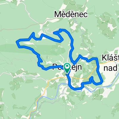
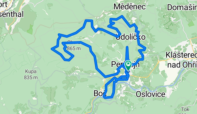
- Perštejn - Mýtinka - Měděnec - Ohře - Perštejn
- Distance
- 21.1 km
- Ascent
- 674 m
- Descent
- 690 m
- Location
- Perštejn, Ústecký kraj, Czechia
- MTB Berganstieg Srni-Klinovec(Keilberg)
- Distance
- 18.3 km
- Ascent
- 897 m
- Descent
- 63 m
- Location
- Perštejn, Ústecký kraj, Czechia
- Okolo Doupovských hor
- Distance
- 102 km
- Ascent
- 859 m
- Descent
- 854 m
- Location
- Perštejn, Ústecký kraj, Czechia
- Bikolka 2016 - den druhý
- Distance
- 64.6 km
- Ascent
- 795 m
- Descent
- 524 m
- Location
- Perštejn, Ústecký kraj, Czechia
- Doupov
- Distance
- 47.7 km
- Ascent
- 640 m
- Descent
- 640 m
- Location
- Perštejn, Ústecký kraj, Czechia
Open it in the app