

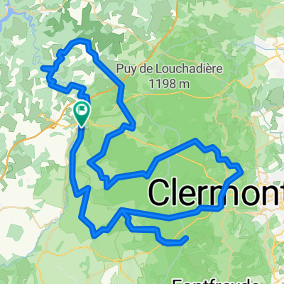
*Vulcania - Plateau de Gergovie (183 Km)
A cycling route starting in Saint-Ours, Auvergne-Rhône-Alpes, France.
Overview
About this route
- -:--
- Duration
- 183 km
- Distance
- 4,304 m
- Ascent
- 4,550 m
- Descent
- ---
- Avg. speed
- 1,396 m
- Max. altitude
Route quality
Waytypes & surfaces along the route
Waytypes
Road
69.5 km
(38 %)
Quiet road
11 km
(6 %)
Undefined
102.5 km
(56 %)
Surfaces
Paved
108 km
(59 %)
Asphalt
108 km
(59 %)
Undefined
75 km
(41 %)
Route highlights
Points of interest along the route
Point of interest after 29.9 km
Col de Guéry (2) Km 30,7 · 1.268 m
Continue with Bikemap
Use, edit, or download this cycling route
You would like to ride *Vulcania - Plateau de Gergovie (183 Km) or customize it for your own trip? Here is what you can do with this Bikemap route:
Free features
- Save this route as favorite or in collections
- Copy & plan your own version of this route
- Split it into stages to create a multi-day tour
- Sync your route with Garmin or Wahoo
Premium features
Free trial for 3 days, or one-time payment. More about Bikemap Premium.
- Navigate this route on iOS & Android
- Export a GPX / KML file of this route
- Create your custom printout (try it for free)
- Download this route for offline navigation
Discover more Premium features.
Get Bikemap PremiumFrom our community
Other popular routes starting in Saint-Ours
 training
- Distance
- 8.6 km
- Ascent
- 133 m
- Descent
- 135 m
- Location
- Saint-Ours, Auvergne-Rhône-Alpes, France
 Puy de Dôme uitgebreid
- Distance
- 58.2 km
- Ascent
- 1,247 m
- Descent
- 1,247 m
- Location
- Saint-Ours, Auvergne-Rhône-Alpes, France
 *Vulcania - Plateau de Gergovie (183 Km)
- Distance
- 183 km
- Ascent
- 4,304 m
- Descent
- 4,550 m
- Location
- Saint-Ours, Auvergne-Rhône-Alpes, France
 23_BL2
- Distance
- 24.5 km
- Ascent
- 527 m
- Descent
- 526 m
- Location
- Saint-Ours, Auvergne-Rhône-Alpes, France
 Place de la République 21, Pontgibaud nach Place de la République 15, Pontgibaud
- Distance
- 82.3 km
- Ascent
- 1,521 m
- Descent
- 1,523 m
- Location
- Saint-Ours, Auvergne-Rhône-Alpes, France
 La boucle des Dômes (boucle n°13) + col
- Distance
- 99.2 km
- Ascent
- 1,204 m
- Descent
- 1,204 m
- Location
- Saint-Ours, Auvergne-Rhône-Alpes, France
 Puy de Dôme basis
- Distance
- 43.1 km
- Ascent
- 778 m
- Descent
- 779 m
- Location
- Saint-Ours, Auvergne-Rhône-Alpes, France
 De D576, Saint-Ours à D576, Saint-Ours
- Distance
- 15.4 km
- Ascent
- 427 m
- Descent
- 427 m
- Location
- Saint-Ours, Auvergne-Rhône-Alpes, France
Open it in the app