
Motala-Göteborg 1
A cycling route starting in Motala, Östergötland County, Sweden.
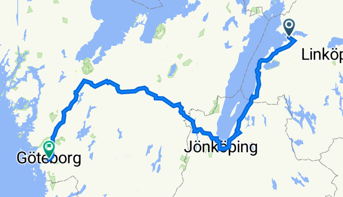
Overview
About this route
- 22 h 22 min
- Duration
- 356.3 km
- Distance
- 2,702 m
- Ascent
- 2,796 m
- Descent
- 15.9 km/h
- Avg. speed
- 310 m
- Max. altitude

Route quality
Waytypes & surfaces along the route
Waytypes
Road
198 km
(56 %)
Path
84 km
(24 %)
Surfaces
Paved
308.5 km
(87 %)
Unpaved
29.8 km
(8 %)
Asphalt
186.9 km
(52 %)
Paved (undefined)
121.5 km
(34 %)
Continue with Bikemap
Use, edit, or download this cycling route
You would like to ride Motala-Göteborg 1 or customize it for your own trip? Here is what you can do with this Bikemap route:
Free features
- Save this route as favorite or in collections
- Copy & plan your own version of this route
- Split it into stages to create a multi-day tour
- Sync your route with Garmin or Wahoo
Premium features
Free trial for 3 days, or one-time payment. More about Bikemap Premium.
- Navigate this route on iOS & Android
- Export a GPX / KML file of this route
- Create your custom printout (try it for free)
- Download this route for offline navigation
Discover more Premium features.
Get Bikemap PremiumFrom our community
Other popular routes starting in Motala
 ostsee20-20 Motala - Askersund
- Distance
- 65.5 km
- Ascent
- 968 m
- Descent
- 974 m
- Location
- Motala, Östergötland County, Sweden
 Vätternrundan 2009
- Distance
- 299.5 km
- Ascent
- 568 m
- Descent
- 569 m
- Location
- Motala, Östergötland County, Sweden
 vaetternrundan
- Distance
- 298.8 km
- Ascent
- 617 m
- Descent
- 620 m
- Location
- Motala, Östergötland County, Sweden
 Vätternrundan 2009
- Distance
- 297.4 km
- Ascent
- 1,022 m
- Descent
- 1,002 m
- Location
- Motala, Östergötland County, Sweden
 2025-Schweden: Von Motala nach Oskarshamn
- Distance
- 341 km
- Ascent
- 2,609 m
- Descent
- 2,697 m
- Location
- Motala, Östergötland County, Sweden
 VR_2018
- Distance
- 296.6 km
- Ascent
- 457 m
- Descent
- 458 m
- Location
- Motala, Östergötland County, Sweden
 Gota Kanal 7a tappa: Motala - Askersund
- Distance
- 73.2 km
- Ascent
- 297 m
- Descent
- 294 m
- Location
- Motala, Östergötland County, Sweden
 S_Vätternrundan
- Distance
- 299.6 km
- Ascent
- 568 m
- Descent
- 569 m
- Location
- Motala, Östergötland County, Sweden
Open it in the app