
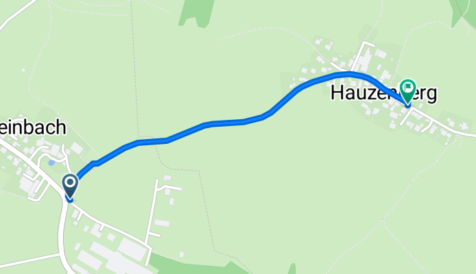
Ernstinger Straße 18, Röhrnbach nach Hauzenberg 9, Waldkirchen
A cycling route starting in Röhrnbach, Bavaria, Germany.
Overview
About this route
- 7 min
- Duration
- 1.1 km
- Distance
- 47 m
- Ascent
- 0 m
- Descent
- 9.5 km/h
- Avg. speed
- 532 m
- Max. altitude
Route quality
Waytypes & surfaces along the route
Waytypes
Quiet road
1 km
(97 %)
Road
0 km
(3 %)
Undefined
0 km
(<1 %)
Surfaces
Paved
0.9 km
(88 %)
Asphalt
0.9 km
(88 %)
Undefined
0.1 km
(12 %)
Continue with Bikemap
Use, edit, or download this cycling route
You would like to ride Ernstinger Straße 18, Röhrnbach nach Hauzenberg 9, Waldkirchen or customize it for your own trip? Here is what you can do with this Bikemap route:
Free features
- Save this route as favorite or in collections
- Copy & plan your own version of this route
- Sync your route with Garmin or Wahoo
Premium features
Free trial for 3 days, or one-time payment. More about Bikemap Premium.
- Navigate this route on iOS & Android
- Export a GPX / KML file of this route
- Create your custom printout (try it for free)
- Download this route for offline navigation
Discover more Premium features.
Get Bikemap PremiumFrom our community
Other popular routes starting in Röhrnbach
 Freyung
- Distance
- 12.1 km
- Ascent
- 290 m
- Descent
- 80 m
- Location
- Röhrnbach, Bavaria, Germany
 PPP2_Rohrnbach_Hlinište_2010_7_26
- Distance
- 36.6 km
- Ascent
- 837 m
- Descent
- 464 m
- Location
- Röhrnbach, Bavaria, Germany
 Tour de Wolf 2019 (komplett)
- Distance
- 203.9 km
- Ascent
- 2,407 m
- Descent
- 2,403 m
- Location
- Röhrnbach, Bavaria, Germany
 Röhrnbach-Grubweg
- Distance
- 49.1 km
- Ascent
- 757 m
- Descent
- 757 m
- Location
- Röhrnbach, Bavaria, Germany
 Bruckmühle 2, Röhrnbach nach Unterhöhenstetten 27, Waldkirchen
- Distance
- 33.2 km
- Ascent
- 591 m
- Descent
- 462 m
- Location
- Röhrnbach, Bavaria, Germany
 Sicklinger Berg Runde
- Distance
- 7.1 km
- Ascent
- 242 m
- Descent
- 241 m
- Location
- Röhrnbach, Bavaria, Germany
 2012+2013 Ilztalbahntrasse
- Distance
- 64.7 km
- Ascent
- 379 m
- Descent
- 469 m
- Location
- Röhrnbach, Bavaria, Germany
 Oberfrauenwald
- Distance
- 31.1 km
- Ascent
- 819 m
- Descent
- 810 m
- Location
- Röhrnbach, Bavaria, Germany
Open it in the app