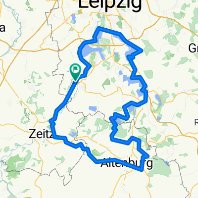
Runde Pegau Monarchenhügel Mondsee Profen
A cycling route starting in Pegau, Saxony, Germany.
Overview
About this route
Around the open-pit mining area of Profen
Werbener Lake
Monarchs Hill
Großgörschen (village museum)
Muschwitz
Mondsee Lake
Profen
partially well passable country road
- -:--
- Duration
- 37.4 km
- Distance
- 110 m
- Ascent
- 112 m
- Descent
- ---
- Avg. speed
- ---
- Max. altitude
Continue with Bikemap
Use, edit, or download this cycling route
You would like to ride Runde Pegau Monarchenhügel Mondsee Profen or customize it for your own trip? Here is what you can do with this Bikemap route:
Free features
- Save this route as favorite or in collections
- Copy & plan your own version of this route
- Sync your route with Garmin or Wahoo
Premium features
Free trial for 3 days, or one-time payment. More about Bikemap Premium.
- Navigate this route on iOS & Android
- Export a GPX / KML file of this route
- Create your custom printout (try it for free)
- Download this route for offline navigation
Discover more Premium features.
Get Bikemap PremiumFrom our community
Other popular routes starting in Pegau
- Martin-Luther-Platz 14, Pegau nach Martin-Luther-Platz 12, Pegau
- Distance
- 29.3 km
- Ascent
- 126 m
- Descent
- 132 m
- Location
- Pegau, Saxony, Germany
- Runde Pegau Monarchenhügel Mondsee Profen
- Distance
- 37.4 km
- Ascent
- 110 m
- Descent
- 112 m
- Location
- Pegau, Saxony, Germany
- Pegau - Halle (Saale) (2.Tag)
- Distance
- 66 km
- Ascent
- 54 m
- Descent
- 90 m
- Location
- Pegau, Saxony, Germany
- Floßgraben-Wanderweg Pegau
- Distance
- 9.3 km
- Ascent
- 20 m
- Descent
- 21 m
- Location
- Pegau, Saxony, Germany
- Kanupark
- Distance
- 17.4 km
- Ascent
- 23 m
- Descent
- 39 m
- Location
- Pegau, Saxony, Germany
- Janine und Petra
- Distance
- 113.8 km
- Ascent
- 308 m
- Descent
- 311 m
- Location
- Pegau, Saxony, Germany
- Elster-Radweg (Tag 2)
- Distance
- 91.9 km
- Ascent
- 494 m
- Descent
- 398 m
- Location
- Pegau, Saxony, Germany
- Pegau - Wittenberg (Kohle Dampf Licht Seen)
- Distance
- 185.8 km
- Ascent
- 719 m
- Descent
- 782 m
- Location
- Pegau, Saxony, Germany
Open it in the app