

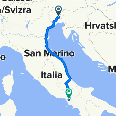
BN_TN_AA_2
A cycling route starting in Tavagnacco, Friuli Venezia Giulia, Italy.
Overview
About this route
- -:--
- Duration
- 40.8 km
- Distance
- 292 m
- Ascent
- 231 m
- Descent
- ---
- Avg. speed
- 211 m
- Max. altitude

Route quality
Waytypes & surfaces along the route
Waytypes
Road
18.4 km
(45 %)
Quiet road
15.1 km
(37 %)
Surfaces
Paved
30.6 km
(75 %)
Unpaved
1.6 km
(4 %)
Asphalt
30.6 km
(75 %)
Ground
0.8 km
(2 %)
Continue with Bikemap
Use, edit, or download this cycling route
You would like to ride BN_TN_AA_2 or customize it for your own trip? Here is what you can do with this Bikemap route:
Free features
- Save this route as favorite or in collections
- Copy & plan your own version of this route
- Sync your route with Garmin or Wahoo
Premium features
Free trial for 3 days, or one-time payment. More about Bikemap Premium.
- Navigate this route on iOS & Android
- Export a GPX / KML file of this route
- Create your custom printout (try it for free)
- Download this route for offline navigation
Discover more Premium features.
Get Bikemap PremiumFrom our community
Other popular routes starting in Tavagnacco
 Alpe_Adria_Santamaria
- Distance
- 37.3 km
- Ascent
- 12 m
- Descent
- 120 m
- Location
- Tavagnacco, Friuli Venezia Giulia, Italy
 Da Via Michelangelo Buonarroti 53, Feletto Umberto a Via Cividina 38, Magnano In Riviera
- Distance
- 16.4 km
- Ascent
- 219 m
- Descent
- 156 m
- Location
- Tavagnacco, Friuli Venezia Giulia, Italy
 Via Giosuè Carducci 49, Tavagnacco a Via Centimolo 71–99, Francolise
- Distance
- 759.8 km
- Ascent
- 2,343 m
- Descent
- 2,423 m
- Location
- Tavagnacco, Friuli Venezia Giulia, Italy
 Lungo il Cornappo, Torre e colline friulane.
- Distance
- 96.5 km
- Ascent
- 1,142 m
- Descent
- 1,144 m
- Location
- Tavagnacco, Friuli Venezia Giulia, Italy
 Udine Izola
- Distance
- 114.6 km
- Ascent
- 703 m
- Descent
- 828 m
- Location
- Tavagnacco, Friuli Venezia Giulia, Italy
 Collio sloveno2 da Mernicco
- Distance
- 84.2 km
- Ascent
- 782 m
- Descent
- 811 m
- Location
- Tavagnacco, Friuli Venezia Giulia, Italy
 BN_TN_AA_2
- Distance
- 40.8 km
- Ascent
- 292 m
- Descent
- 231 m
- Location
- Tavagnacco, Friuli Venezia Giulia, Italy
 Via della Roggia 1, Tavagnacco a Via Dante Alighieri 93, Tavagnacco
- Distance
- 45.6 km
- Ascent
- 963 m
- Descent
- 966 m
- Location
- Tavagnacco, Friuli Venezia Giulia, Italy
Open it in the app