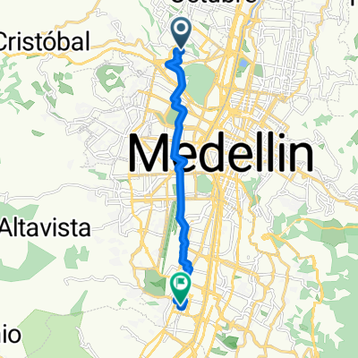
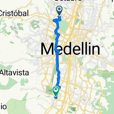
cicloruta Aeroparque, ruta N
A cycling route starting in Medellín, Antioquia, Colombia.
Overview
About this route
- 34 min
- Duration
- 8.5 km
- Distance
- 41 m
- Ascent
- 88 m
- Descent
- 15.2 km/h
- Avg. speed
- 1,526 m
- Max. altitude
Continue with Bikemap
Use, edit, or download this cycling route
You would like to ride cicloruta Aeroparque, ruta N or customize it for your own trip? Here is what you can do with this Bikemap route:
Free features
- Save this route as favorite or in collections
- Copy & plan your own version of this route
- Sync your route with Garmin or Wahoo
Premium features
Free trial for 3 days, or one-time payment. More about Bikemap Premium.
- Navigate this route on iOS & Android
- Export a GPX / KML file of this route
- Create your custom printout (try it for free)
- Download this route for offline navigation
Discover more Premium features.
Get Bikemap PremiumFrom our community
Other popular routes starting in Medellín
- Medellin BUS Süd
- Distance
- 8.2 km
- Ascent
- 87 m
- Descent
- 75 m
- Location
- Medellín, Antioquia, Colombia
- cicloruta Aeroparque, ruta N
- Distance
- 8.5 km
- Ascent
- 41 m
- Descent
- 88 m
- Location
- Medellín, Antioquia, Colombia
- Paseo increíble en Medellín
- Distance
- 38.3 km
- Ascent
- 1,215 m
- Descent
- 1,225 m
- Location
- Medellín, Antioquia, Colombia
- Route to Medellín
- Distance
- 9.8 km
- Ascent
- 84 m
- Descent
- 48 m
- Location
- Medellín, Antioquia, Colombia
- De Carrera 55 2459, Medellín a Carrera 65C 16a
- Distance
- 0.8 km
- Ascent
- 0 m
- Descent
- 0 m
- Location
- Medellín, Antioquia, Colombia
- De Carrera 83A 32-15, Medellín a Carrera 83A #32b-80, Medellín
- Distance
- 6.7 km
- Ascent
- 140 m
- Descent
- 118 m
- Location
- Medellín, Antioquia, Colombia
- euro frontera
- Distance
- 13.8 km
- Ascent
- 183 m
- Descent
- 199 m
- Location
- Medellín, Antioquia, Colombia
- La Clara
- Distance
- 67.9 km
- Ascent
- 801 m
- Descent
- 757 m
- Location
- Medellín, Antioquia, Colombia
Open it in the app