
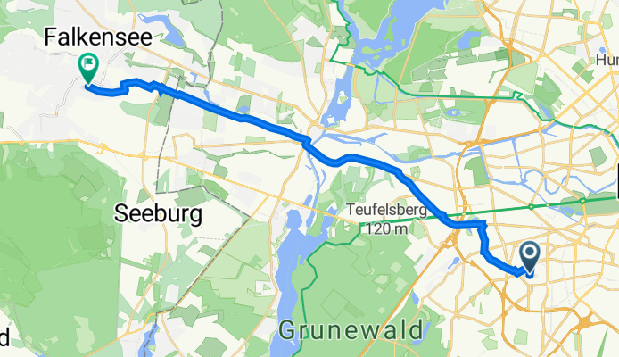
Pfalzburger Straße 34, Berlin nach Clara-Zetkin-Straße 30a, Falkensee
A cycling route starting in Wilmersdorf, State of Berlin, Germany.
Overview
About this route
- 58 min
- Duration
- 20.4 km
- Distance
- 85 m
- Ascent
- 133 m
- Descent
- 21 km/h
- Avg. speed
- 77 m
- Max. altitude

Route quality
Waytypes & surfaces along the route
Waytypes
Road
7 km
(34 %)
Busy road
3.8 km
(19 %)
Surfaces
Paved
19.9 km
(97 %)
Asphalt
14.6 km
(71 %)
Paving stones
5.3 km
(26 %)
Continue with Bikemap
Use, edit, or download this cycling route
You would like to ride Pfalzburger Straße 34, Berlin nach Clara-Zetkin-Straße 30a, Falkensee or customize it for your own trip? Here is what you can do with this Bikemap route:
Free features
- Save this route as favorite or in collections
- Copy & plan your own version of this route
- Sync your route with Garmin or Wahoo
Premium features
Free trial for 3 days, or one-time payment. More about Bikemap Premium.
- Navigate this route on iOS & Android
- Export a GPX / KML file of this route
- Create your custom printout (try it for free)
- Download this route for offline navigation
Discover more Premium features.
Get Bikemap PremiumFrom our community
Other popular routes starting in Wilmersdorf
 S/U Bundesplatz -> Ruhlsdorf -> Genshagen -> Zossen -> Mittenwalde -> Tollkrug -> S Lichtenrade -> S Südkreuz
- Distance
- 86.7 km
- Ascent
- 111 m
- Descent
- 116 m
- Location
- Wilmersdorf, State of Berlin, Germany
 Gröberner Runde
- Distance
- 80.8 km
- Ascent
- 96 m
- Descent
- 98 m
- Location
- Wilmersdorf, State of Berlin, Germany
 B-O 01 Berlin - Oranienburg
- Distance
- 49.1 km
- Ascent
- 51 m
- Descent
- 59 m
- Location
- Wilmersdorf, State of Berlin, Germany
 Blankenseer Runde
- Distance
- 96.8 km
- Ascent
- 152 m
- Descent
- 152 m
- Location
- Wilmersdorf, State of Berlin, Germany
 Berlin-Ketzin-Berlin
- Distance
- 94.6 km
- Ascent
- 185 m
- Descent
- 185 m
- Location
- Wilmersdorf, State of Berlin, Germany
 S/U Bundesplatz -> Ruhlsdorf -> Genshagen -> Zossen -> Mittenwalde -> Tollkrug -> S Lichtenrade -> S Südkreuz
- Distance
- 86.6 km
- Ascent
- 180 m
- Descent
- 183 m
- Location
- Wilmersdorf, State of Berlin, Germany
 Potsdamer Seen und Schlösser
- Distance
- 84 km
- Ascent
- 346 m
- Descent
- 336 m
- Location
- Wilmersdorf, State of Berlin, Germany
 Große Runde
- Distance
- 64.5 km
- Ascent
- 199 m
- Descent
- 199 m
- Location
- Wilmersdorf, State of Berlin, Germany
Open it in the app